Durrow geodata
Durrow (Leinster) is a populated place; located in Ireland in Europe/Dublin (GMT+1) time zone. With population of 843 people, there are 382 cities with bigger population in this country. Compared to other cities in Ireland, 66.4% of cities are located further ↑North; 50.1% of cities are located further ←West and 77.8% of cities have lower elevation than Durrow. Note1


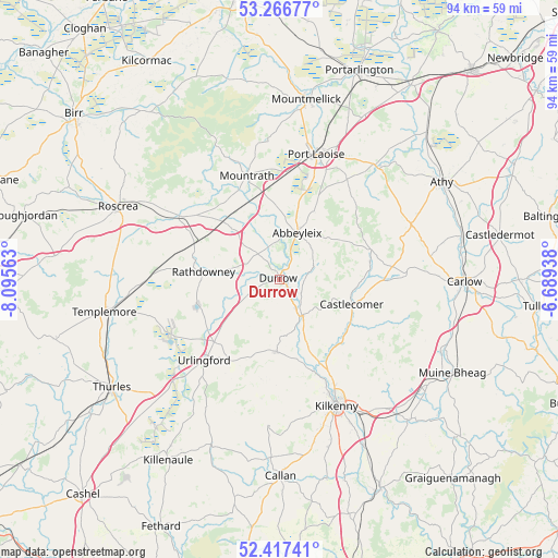
Durrow GPS coordinates[2]
52° 50' 39.012" North, 7° 23' 33" West
| Map corner | latitude | longitude |
|---|---|---|
| Upper-left | 53.26677°, | -8.09563° |
| Center: | 52.84417°, | -7.3925° |
| Lower-right: | 52.41741°, | -6.68938° |
| Map W x H: | 94.4×94.4 km | = 58.7×58.7mi |
| max Lat: | 55.25° ⇑66.4% North |
| Durrow: | 52.84417° |
| min Lat: | ⇓33.6% South 51.52487° |
| min Long | Durrow | max Long |
| -10.26889° | -7.3925° | -6.04944° |
| W 50.1%⇐ | ⇒49.9% E |
Elevation
Elevation of Durrow is 85 m = 279 ft, and this is 30.5 m = 100 ft above average elevation for this country.
| Max E: |
262 m = 860 ft | 22.2% |
| Durrow | 85 m 279 ft | |
| Avg. | 54.5 m = 179 ft | |
Min E: |
0 m = 0 ft | 77.8% |
See also: Ireland elevation on elevation.city.
Geographical zone
Durrow is located in North temperate zone (between Tropic of Cancer and the Arctic Circle). Distance of this North polar circle is 1525.5 km =947.9 mi to North.| Distance of | km | miles | from Durrow |
|---|---|---|---|
| North Pole | 4131.3 | 2567.1 | to North |
| Arctic Circle | 1525.5 | 947.9 | to North |
| Tropic Cancer | 3269.8 | 2031.8 | to South |
| Equator | 5875.7 | 3651 | to South |


Nearby cities:
15 places around Durrow: (largest is in red/bold)
• Abbeyleix
8.3 km =5.2 mi,  22°
22°
• Ballylinan
26.1 km =16.2 mi,  64°
64°
• Ballyragget
7.4 km =4.6 mi,  145°
145°
• Castlecomer
12.9 km =8 mi,  109°
109°
• Freshford
12.2 km =7.6 mi,  182°
182°
• Kilkenny
23.1 km =14.4 mi,  155°
155°
• Moneenroe
15.9 km =9.9 mi,  91°
91°
• Mountrath
18 km =11.2 mi,  342°
342°
• Portlaoise
22 km =13.7 mi, 16°
• Rathdowney
12.7 km =7.9 mi,  275°
275°
• Roscrea
29.9 km =18.6 mi,  293°
293°
• Stradbally
24.9 km =15.5 mi,  40°
40°
• Templemore
30.2 km =18.8 mi,  259°
259°
• Twomileborris
29.2 km =18.1 mi,  228°
228°
• Urlingford
18.8 km =11.7 mi,  222°
222°
Sources, notices
• [Note1] Compared only with cities in Ireland existing in our database
• [Src1] Map data: © OpenStreetMap contributors (CC-BY-SA)
• [Src2] Other city data from geonames.org with taken over terms of usage.
• [Src3] Geographical zone / Annual Mean Temperature by Robert A. Rohde @ Wikipedia
