Mountrath geodata
Mountrath (Leinster) is a populated place; located in Ireland in Europe/Dublin (GMT+0) time zone. With population of 1,661 people, there are 254 cities with bigger population in this country. Compared to other cities in Ireland, 61.1% of cities are located further ↑North; 51.6% of cities are located further →East and 87.1% of cities have lower elevation than Mountrath. Note1


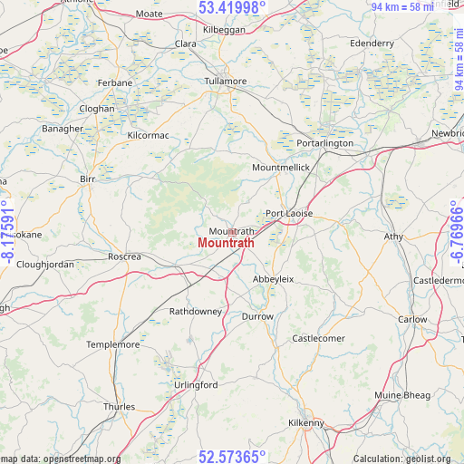
Mountrath GPS coordinates[2]
52° 59' 56.004" North, 7° 28' 22.008" West
| Map corner | latitude | longitude |
|---|---|---|
| Upper-left | 53.41998°, | -8.17591° |
| Center: | 52.99889°, | -7.47278° |
| Lower-right: | 52.57365°, | -6.76966° |
| Map W x H: | 94.1×94.1 km | = 58.5×58.5mi |
| max Lat: | 55.25° ⇑61.1% North |
| Mountrath: | 52.99889° |
| min Lat: | ⇓38.9% South 51.52487° |
| min Long | Mountrath | max Long |
| -10.26889° | -7.47278° | -6.04944° |
| W 48.4%⇐ | ⇒51.6% E |
Elevation
Elevation of Mountrath is 100 m = 328 ft, and this is 45.5 m = 149 ft above average elevation for this country.
| Max E: |
262 m = 860 ft | 12.9% |
| Mountrath | 100 m 328 ft | |
| Avg. | 54.5 m = 179 ft | |
Min E: |
0 m = 0 ft | 87.1% |
See also: Ireland elevation on elevation.city.
Geographical zone
Mountrath is located in North temperate zone (between Tropic of Cancer and the Arctic Circle). Distance of this North polar circle is 1508.2 km =937.2 mi to North.| Distance of | km | miles | from Mountrath |
|---|---|---|---|
| North Pole | 4114.1 | 2556.4 | to North |
| Arctic Circle | 1508.2 | 937.2 | to North |
| Tropic Cancer | 3287 | 2042.4 | to South |
| Equator | 5892.9 | 3661.7 | to South |


Nearby cities:
15 places around Mountrath: (largest is in red/bold)
• Abbeyleix
12.8 km =8 mi,  137°
137°
• Ballylinan
29.5 km =18.3 mi,  101°
101°
• Ballyragget
25.2 km =15.7 mi,  157°
157°
• Castlecomer
27.7 km =17.2 mi, 140°
• Clonaslee
16.9 km =10.5 mi,  348°
348°
• Durrow
18 km =11.2 mi, 162°
• Kilcormac
25.8 km =16 mi,  319°
319°
• Killenard
26.3 km =16.3 mi,  55°
55°
• Moneenroe
27.7 km =17.2 mi,  129°
129°
• Mountmellick
16.3 km =10.1 mi,  38°
38°
• Portarlington
26.1 km =16.2 mi,  46°
46°
• Portlaoise
12.2 km =7.6 mi,  71°
71°
• Rathdowney
17.6 km =10.9 mi,  204°
204°
• Roscrea
22.7 km =14.1 mi,  256°
256°
• Stradbally
21.5 km =13.4 mi,  85°
85°
Sources, notices
• [Note1] Compared only with cities in Ireland existing in our database
• [Src1] Map data: © OpenStreetMap contributors (CC-BY-SA)
• [Src2] Other city data from geonames.org with taken over terms of usage.
• [Src3] Geographical zone / Annual Mean Temperature by Robert A. Rohde @ Wikipedia
