Urlingford geodata
Urlingford (Leinster) is a populated place; located in Ireland in Europe/Dublin (GMT+1) time zone. With population of 973 people, there are 354 cities with bigger population in this country. Compared to other cities in Ireland, 70.8% of cities are located further ↑North; 53.7% of cities are located further →East and 94.7% of cities have lower elevation than Urlingford. Note1


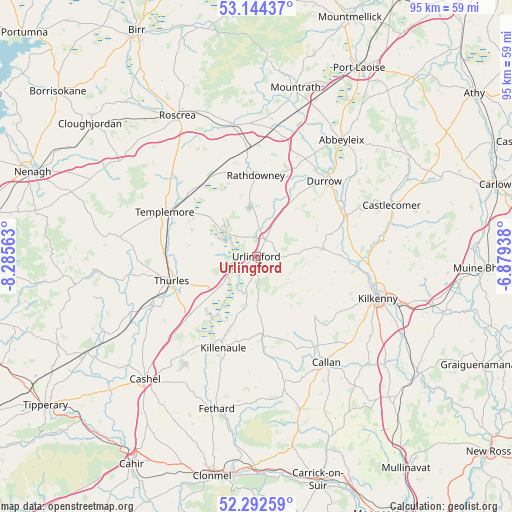
Urlingford GPS coordinates[2]
52° 43' 14.016" North, 7° 34' 57" West
| Map corner | latitude | longitude |
|---|---|---|
| Upper-left | 53.14437°, | -8.28563° |
| Center: | 52.72056°, | -7.5825° |
| Lower-right: | 52.29259°, | -6.87938° |
| Map W x H: | 94.7×94.7 km | = 58.8×58.8mi |
| max Lat: | 55.25° ⇑70.8% North |
| Urlingford: | 52.72056° |
| min Lat: | ⇓29.2% South 51.52487° |
| min Long | Urlingford | max Long |
| -10.26889° | -7.5825° | -6.04944° |
| W 46.3%⇐ | ⇒53.7% E |
Elevation
Elevation of Urlingford is 122 m = 400 ft, and this is 67.5 m = 221 ft above average elevation for this country.
| Max E: |
262 m = 860 ft | 5.3% |
| Urlingford | 122 m 400 ft | |
| Avg. | 54.5 m = 179 ft | |
Min E: |
0 m = 0 ft | 94.7% |
See also: Ireland elevation on elevation.city.
Geographical zone
Urlingford is located in North temperate zone (between Tropic of Cancer and the Arctic Circle). Distance of this North polar circle is 1539.2 km =956.4 mi to North.| Distance of | km | miles | from Urlingford |
|---|---|---|---|
| North Pole | 4145.1 | 2575.6 | to North |
| Arctic Circle | 1539.2 | 956.4 | to North |
| Tropic Cancer | 3256.1 | 2023.2 | to South |
| Equator | 5862 | 3642.5 | to South |


Nearby cities:
15 places around Urlingford: (largest is in red/bold)
• Abbeyleix
26.7 km =16.6 mi,  36°
36°
• Ballyragget
18.6 km =11.6 mi,  65°
65°
• Borrisoleigh
25.2 km =15.7 mi,  278°
278°
• Callan
23.4 km =14.5 mi,  146°
146°
• Castlecomer
26.8 km =16.7 mi, 69°
• Durrow
18.8 km =11.7 mi, 42°
• Fethard
29.1 km =18.1 mi,  194°
194°
• Freshford
12.5 km =7.8 mi,  83°
83°
• Holycross
20.9 km =13 mi,  244°
244°
• Kilkenny
23.5 km =14.6 mi,  108°
108°
• Killenaule
18 km =11.2 mi,  199°
199°
• Rathdowney
14.9 km =9.3 mi,  0°
0°
• Templemore
18.8 km =11.7 mi,  295°
295°
• Thurles
15.4 km =9.6 mi,  253°
253°
• Twomileborris
10.7 km =6.6 mi, 239°
Sources, notices
• [Note1] Compared only with cities in Ireland existing in our database
• [Src1] Map data: © OpenStreetMap contributors (CC-BY-SA)
• [Src2] Other city data from geonames.org with taken over terms of usage.
• [Src3] Geographical zone / Annual Mean Temperature by Robert A. Rohde @ Wikipedia
