Rosh Pinna geodata
Rosh Pinna (Northern District) is a populated place; located in Israel in Asia/Jerusalem (GMT+3) time zone. With population of 2,492 people, there are 133 cities with bigger population in this country. Compared to other cities in Israel, 90.5% of cities are located further ↓South; 96.4% of cities are located further ←West and 77.5% of cities have lower elevation than Rosh Pinna. Note1


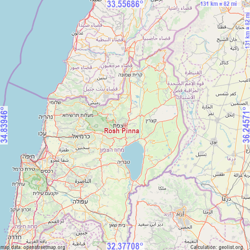
Rosh Pinna GPS coordinates[2]
32° 58' 8.184" North, 35° 32' 33.288" East
| Map corner | latitude | longitude |
|---|---|---|
| Upper-left | 33.55686°, | 34.83946° |
| Center: | 32.96894°, | 35.54258° |
| Lower-right: | 32.37708°, | 36.24571° |
| Map W x H: | 131.2×131.2 km | = 81.5×81.5mi |
| max Lat: | 33.27918° ⇑9.5% North |
| Rosh Pinna: | 32.96894° |
| min Lat: | ⇓90.5% South 29.55805° |
| min Long | Rosh Pinna | max Long |
| 34.57149° | 35.54258° | 35.81084° |
| W 96.4%⇐ | ⇒3.6% E |
Elevation
Elevation of Rosh Pinna is 391 m = 1283 ft, and this is 167.6 m = 550 ft above average elevation for this country.
| Max E: |
988 m = 3241 ft | 22.5% |
| Rosh Pinna | 391 m 1283 ft | |
| Avg. | 223.4 m = 733 ft | |
Min E: |
-380 m = -1247 ft | 77.5% |
See also: Israel elevation on elevation.city.
Geographical zone
Rosh Pinna is located in North temperate zone (between Tropic of Cancer and the Arctic Circle). Distance of this Northern Tropic circle is 1059.9 km =658.6 mi to South.| Distance of | km | miles | from Rosh Pinna |
|---|---|---|---|
| North Pole | 6341.3 | 3940.3 | to North |
| Arctic Circle | 3735.4 | 2321.1 | to North |
| Tropic Cancer | 1059.9 | 658.6 | to South |
| Equator | 3665.8 | 2277.8 | to South |


Nearby cities:
15 places around Rosh Pinna: (largest is in red/bold)
• Al Buţayḩah
10.7 km =6.6 mi,  128°
128°
• Beit Jann
15 km =9.3 mi,  268°
268°
• Buqei‘a
19.5 km =12.1 mi, 272°
• Deir Ḥannā
20.5 km =12.7 mi,  234°
234°
• Jīsh
10.7 km =6.6 mi,  303°
303°
• Karmi’el
22.9 km =14.2 mi,  255°
255°
• Maghār
15.4 km =9.6 mi,  235°
235°
• Naḥf
21.4 km =13.3 mi, 259°
• Pasuta
23.5 km =14.6 mi,  292°
292°
• Safed
4.4 km =2.7 mi, 263°
• Sallama
18.2 km =11.3 mi, 242°
• Sājūr
19 km =11.8 mi, 261°
• Tiberias
19.7 km =12.2 mi,  183°
183°
• Ḥurfeish
18.9 km =11.7 mi, 286°
• ‘Eilabun
19.8 km =12.3 mi,  222°
222°
Sources, notices
• [Note1] Compared only with cities in Israel existing in our database
• [Src1] Map data: © OpenStreetMap contributors (CC-BY-SA)
• [Src2] Other city data from geonames.org with taken over terms of usage.
• [Src3] Geographical zone / Annual Mean Temperature by Robert A. Rohde @ Wikipedia
