Safed geodata
Safed (Northern District) is a populated place; located in Israel in Asia/Jerusalem (GMT+3) time zone. With population of 27,816 people, there are 48 cities with bigger population in this country. Compared to other cities in Israel, 89.9% of cities are located further ↓South; 94.1% of cities are located further ←West and 96.4% of cities have lower elevation than Safed. Note1


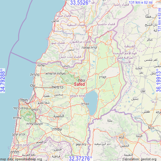
Safed GPS coordinates[2]
32° 57' 52.74" North, 35° 29' 45.6" East
| Map corner | latitude | longitude |
|---|---|---|
| Upper-left | 33.5526°, | 34.79288° |
| Center: | 32.96465°, | 35.496° |
| Lower-right: | 32.37276°, | 36.19913° |
| Map W x H: | 131.2×131.2 km | = 81.5×81.5mi |
| max Lat: | 33.27918° ⇑10.1% North |
| Safed: | 32.96465° |
| min Lat: | ⇓89.9% South 29.55805° |
| min Long | Safed | max Long |
| 34.57149° | 35.496° | 35.81084° |
| W 94.1%⇐ | ⇒5.9% E |
Elevation
Elevation of Safed is 779 m = 2556 ft, and this is 555.6 m = 1823 ft above average elevation for this country.
| Max E: |
988 m = 3241 ft | 3.6% |
| Safed | 779 m 2556 ft | |
| Avg. | 223.4 m = 733 ft | |
Min E: |
-380 m = -1247 ft | 96.4% |
See also: Israel elevation on elevation.city.
Geographical zone
Safed is located in North temperate zone (between Tropic of Cancer and the Arctic Circle). Distance of this Northern Tropic circle is 1059.4 km =658.3 mi to South.| Distance of | km | miles | from Safed |
|---|---|---|---|
| North Pole | 6341.7 | 3940.5 | to North |
| Arctic Circle | 3735.8 | 2321.3 | to North |
| Tropic Cancer | 1059.4 | 658.3 | to South |
| Equator | 3665.3 | 2277.5 | to South |


Nearby cities:
15 places around Safed: (largest is in red/bold)
• Al Buţayḩah
14.1 km =8.8 mi,  116°
116°
• Beit Jann
10.7 km =6.6 mi,  269°
269°
• Buqei‘a
15.2 km =9.4 mi,  275°
275°
• Deir Ḥannā
16.8 km =10.4 mi,  227°
227°
• Jīsh
7.9 km =4.9 mi,  324°
324°
• Karmi’el
18.6 km =11.6 mi,  253°
253°
• Maghār
11.8 km =7.3 mi,  224°
224°
• Naḥf
17.1 km =10.6 mi,  258°
258°
• Pasuta
19.8 km =12.3 mi,  298°
298°
• Rosh Pinna
4.4 km =2.7 mi,  83°
83°
• Sallama
14.2 km =8.8 mi,  236°
236°
• Sājūr
14.6 km =9.1 mi, 260°
• Tiberias
19.5 km =12.1 mi,  170°
170°
• Ḥurfeish
15 km =9.3 mi,  292°
292°
• ‘Eilabun
16.8 km =10.4 mi,  212°
212°
Sources, notices
• [Note1] Compared only with cities in Israel existing in our database
• [Src1] Map data: © OpenStreetMap contributors (CC-BY-SA)
• [Src2] Other city data from geonames.org with taken over terms of usage.
• [Src3] Geographical zone / Annual Mean Temperature by Robert A. Rohde @ Wikipedia
