Eilat geodata
Eilat (Southern District) is a populated place; located in Israel in Asia/Jerusalem (GMT+3) time zone. With population of 45,588 people, there are 31 cities with bigger population in this country. Compared to other cities in Israel, 100% of cities are located further ↑North; 64.5% of cities are located further →East and 62.7% of cities have higher elevation than Eilat. Note1


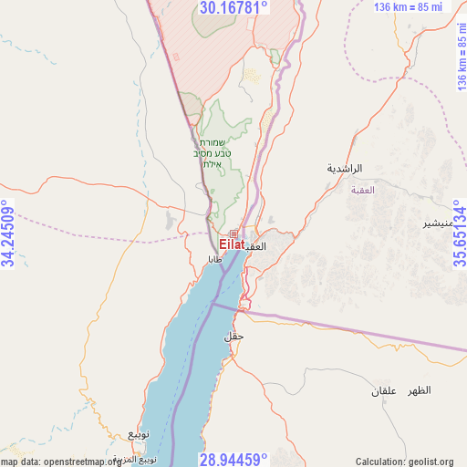
Eilat GPS coordinates[2]
29° 33' 28.98" North, 34° 56' 53.556" East
| Map corner | latitude | longitude |
|---|---|---|
| Upper-left | 30.16781°, | 34.24509° |
| Center: | 29.55805°, | 34.94821° |
| Lower-right: | 28.94459°, | 35.65134° |
| Map W x H: | 136×136 km | = 84.5×84.5mi |
| max Lat: | 33.27918° ⇑100% North |
| Eilat: | 29.55805° |
| min Lat: | ⇓0% South 29.55805° |
| min Long | Eilat | max Long |
| 34.57149° | 34.94821° | 35.81084° |
| W 35.5%⇐ | ⇒64.5% E |
Elevation
Elevation of Eilat is 63 m = 207 ft, and this is 160.4 m = 526 ft below average elevation for this country.
| Max E: |
988 m = 3241 ft | 62.7% |
| Avg. | 223.4 m = 733 ft | |
| Eilat | 63 m = 207 ft | |
Min E: |
-380 m = -1247 ft | 37.3% |
See also: Eilat elevation on elevation.city.
Geographical zone
Eilat is located in North temperate zone (between Tropic of Cancer and the Arctic Circle). Distance of this Northern Tropic circle is 680.6 km =422.9 mi to South.| Distance of | km | miles | from Eilat |
|---|---|---|---|
| North Pole | 6720.5 | 4175.9 | to North |
| Arctic Circle | 4114.6 | 2556.7 | to North |
| Tropic Cancer | 680.6 | 422.9 | to South |
| Equator | 3286.5 | 2042.1 | to South |


Nearby cities:
15 places around Eilat: (largest is in red/bold)
• Arad
190.8 km =118.6 mi,  7°
7°
• Ashkelon
237.5 km =147.6 mi,  351°
351°
• Beersheba
188.9 km =117.4 mi,  355°
355°
• Dimona
168.4 km =104.6 mi,  2°
2°
• Lehavim
202.2 km =125.6 mi, 356°
• Midreshet Ben-Gurion
144.7 km =89.9 mi, 353°
• Mitzpe Ramon
117.8 km =73.2 mi, 353°
• Netivot
210.2 km =130.6 mi, 350°
• Ofaqim
197.8 km =122.9 mi, 350°
• Qiryat Gat
228.8 km =142.2 mi, 355°
• Rahat
205.1 km =127.4 mi, 354°
• Sederot
221.3 km =137.5 mi, 351°
• Yeroẖam
159 km =98.8 mi, 359°
• ‘En Boqeq
186.8 km =116.1 mi, 12°
• ‘En Gedi
214.7 km =133.4 mi, 11°
Sources, notices
• [Note1] Compared only with cities in Israel existing in our database
• [Src1] Map data: © OpenStreetMap contributors (CC-BY-SA)
• [Src2] Other city data from geonames.org with taken over terms of usage.
• [Src3] Geographical zone / Annual Mean Temperature by Robert A. Rohde @ Wikipedia
