Murudeshwara geodata
Murudeshwara (Karnataka) is a religious populated place; located in India in Asia/Kolkata (GMT+5.5) time zone. With population of 17,938 people, there are 2206 cities with bigger population in this country. Compared to other cities in India, 83.2% of cities are located further ↑North; 86.9% of cities are located further →East and 89.3% of cities have higher elevation than Murudeshwara. Note1


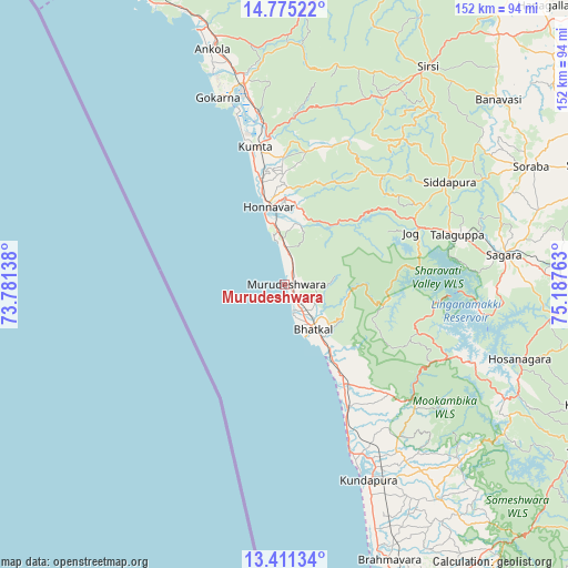
Murudeshwara GPS coordinates[2]
14° 5' 39.48" North, 74° 29' 4.2" East
| Map corner | latitude | longitude |
|---|---|---|
| Upper-left | 14.77522°, | 73.78138° |
| Center: | 14.0943°, | 74.4845° |
| Lower-right: | 13.41134°, | 75.18763° |
| Map W x H: | 151.6×151.7 km | = 94.2×94.3mi |
| max Lat: | 34.9274° ⇑83.2% North |
| Murudeshwara: | 14.0943° |
| min Lat: | ⇓16.8% South 8.09008° |
| min Long | Murudeshwara | max Long |
| 68.82655° | 74.4845° | 96.81° |
| W 13.1%⇐ | ⇒86.9% E |
Elevation
Elevation of Murudeshwara is 19 m = 62 ft, and this is 276.6 m = 907 ft below average elevation for this country.
| Max E: |
3681 m = 12077 ft | 89.3% |
| Avg. | 295.6 m = 970 ft | |
| Murudeshwara | 19 m = 62 ft | |
Min E: |
1 m = 3 ft | 10.7% |
See also: India elevation on elevation.city.
Geographical zone
Murudeshwara is located in North Torrid zone (between Equator and Tropic of Cancer). Distance of this Northern Tropic circle is 1038.8 km =645.5 mi to North.| Distance of | km | miles | from Murudeshwara |
|---|---|---|---|
| North Pole | 8439.9 | 5244.3 | to North |
| Arctic Circle | 5834 | 3625.1 | to North |
| Tropic Cancer | 1038.8 | 645.5 | to North |
| Equator | 1567.1 | 973.8 | to South |


Nearby cities:
15 places around Murudeshwara: (largest is in red/bold)
• Ankola
65.9 km =40.9 mi,  342°
342°
• Bhatkal
14.3 km =8.9 mi,  147°
147°
• Byndoor
30 km =18.6 mi, 147°
• Coondapoor
56.1 km =34.9 mi,  156°
156°
• Gangolli
53.3 km =33.1 mi, 157°
• Gokarna
53.8 km =33.4 mi, 340°
• Honāvar
21.2 km =13.2 mi,  348°
348°
• Hosanagara
65.8 km =40.9 mi,  107°
107°
• Hosangadi
67.2 km =41.8 mi,  131°
131°
• Kumta
37.8 km =23.5 mi, 349°
• Malpe
86.1 km =53.5 mi, 164°
• Siddāpur
52.1 km =32.4 mi,  57°
57°
• Sirsi
69.7 km =43.3 mi,  32°
32°
• Sorab
72.8 km =45.2 mi, 63°
• Sāgar
59.2 km =36.8 mi,  82°
82°
Sources, notices
• [Note1] Compared only with cities in India existing in our database
• [Src1] Map data: © OpenStreetMap contributors (CC-BY-SA)
• [Src2] Other city data from geonames.org with taken over terms of usage.
• [Src3] Geographical zone / Annual Mean Temperature by Robert A. Rohde @ Wikipedia
