Sorab geodata
Sorab (Karnataka) is a populated place; located in India in Asia/Kolkata (GMT+5.5) time zone. With population of 7,088 people, there are 3205 cities with bigger population in this country. Compared to other cities in India, 82.6% of cities are located further ↑North; 82% of cities are located further →East and 87.8% of cities have lower elevation than Sorab. Note1


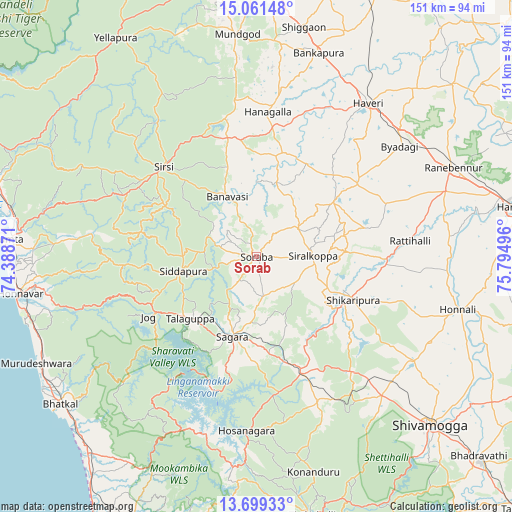
Sorab GPS coordinates[2]
14° 22' 53.184" North, 75° 5' 30.588" East
| Map corner | latitude | longitude |
|---|---|---|
| Upper-left | 15.06148°, | 74.38871° |
| Center: | 14.38144°, | 75.09183° |
| Lower-right: | 13.69933°, | 75.79496° |
| Map W x H: | 151.5×151.5 km | = 94.1×94.1mi |
| max Lat: | 34.9274° ⇑82.6% North |
| Sorab: | 14.38144° |
| min Lat: | ⇓17.4% South 8.09008° |
| min Long | Sorab | max Long |
| 68.82655° | 75.09183° | 96.81° |
| W 18%⇐ | ⇒82% E |
Elevation
Elevation of Sorab is 590 m = 1936 ft, and this is 294.4 m = 966 ft above average elevation for this country.
| Max E: |
3681 m = 12077 ft | 12.2% |
| Sorab | 590 m 1936 ft | |
| Avg. | 295.6 m = 970 ft | |
Min E: |
1 m = 3 ft | 87.8% |
See also: India elevation on elevation.city.
Geographical zone
Sorab is located in North Torrid zone (between Equator and Tropic of Cancer). Distance of this Northern Tropic circle is 1006.9 km =625.7 mi to North.| Distance of | km | miles | from Sorab |
|---|---|---|---|
| North Pole | 8408 | 5224.5 | to North |
| Arctic Circle | 5802.1 | 3605.3 | to North |
| Tropic Cancer | 1006.9 | 625.7 | to North |
| Equator | 1599.1 | 993.6 | to South |


Nearby cities:
15 places around Sorab: (largest is in red/bold)
• Beltangadi
49.6 km =30.8 mi,  153°
153°
• Byādgi
53.5 km =33.2 mi,  52°
52°
• Hirekerūr
33.7 km =20.9 mi,  75°
75°
• Honnāli
61.7 km =38.3 mi,  104°
104°
• Hosanagara
52.1 km =32.4 mi,  183°
183°
• Hāngal
42.8 km =26.6 mi,  4°
4°
• Hāveri
56.8 km =35.3 mi,  36°
36°
• Kumsi
49.2 km =30.6 mi,  137°
137°
• Mundgod
65.9 km =40.9 mi,  354°
354°
• Nyāmti
58.3 km =36.2 mi,  116°
116°
• Rānībennur
63.8 km =39.6 mi,  65°
65°
• Shikārpur
31.1 km =19.3 mi,  113°
113°
• Siddāpur
21.7 km =13.5 mi,  258°
258°
• Sirsi
38.3 km =23.8 mi,  313°
313°
• Sāgar
25 km =15.5 mi,  195°
195°
Sources, notices
• [Note1] Compared only with cities in India existing in our database
• [Src1] Map data: © OpenStreetMap contributors (CC-BY-SA)
• [Src2] Other city data from geonames.org with taken over terms of usage.
• [Src3] Geographical zone / Annual Mean Temperature by Robert A. Rohde @ Wikipedia
