Honāvar geodata
Honāvar (Karnataka) is a populated place; located in India in Asia/Kolkata (GMT+5.5) time zone. With population of 18,392 people, there are 2172 cities with bigger population in this country. Compared to other cities in India, 82.8% of cities are located further ↑North; 87.2% of cities are located further →East and 88.1% of cities have higher elevation than Honāvar. Note1


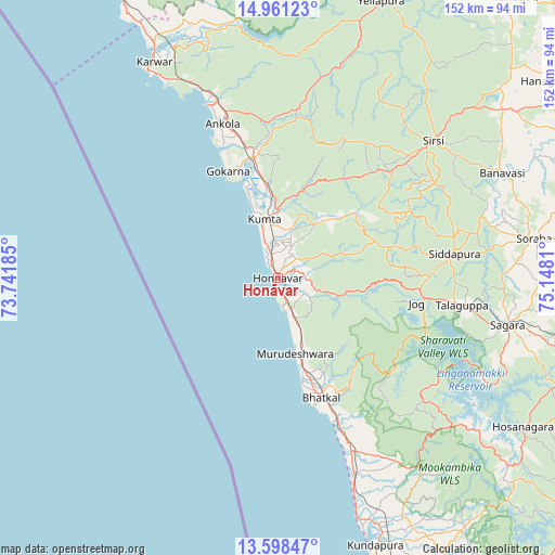
Honāvar GPS coordinates[2]
14° 16' 51.168" North, 74° 26' 41.892" East
| Map corner | latitude | longitude |
|---|---|---|
| Upper-left | 14.96123°, | 73.74185° |
| Center: | 14.28088°, | 74.44497° |
| Lower-right: | 13.59847°, | 75.1481° |
| Map W x H: | 151.5×151.5 km | = 94.1×94.1mi |
| max Lat: | 34.9274° ⇑82.8% North |
| Honāvar: | 14.28088° |
| min Lat: | ⇓17.2% South 8.09008° |
| min Long | Honāvar | max Long |
| 68.82655° | 74.44497° | 96.81° |
| W 12.8%⇐ | ⇒87.2% E |
Elevation
Elevation of Honāvar is 22 m = 72 ft, and this is 273.6 m = 898 ft below average elevation for this country.
| Max E: |
3681 m = 12077 ft | 88.1% |
| Avg. | 295.6 m = 970 ft | |
| Honāvar | 22 m = 72 ft | |
Min E: |
1 m = 3 ft | 11.9% |
See also: India elevation on elevation.city.
Geographical zone
Honāvar is located in North Torrid zone (between Equator and Tropic of Cancer). Distance of this Northern Tropic circle is 1018 km =632.6 mi to North.| Distance of | km | miles | from Honāvar |
|---|---|---|---|
| North Pole | 8419.2 | 5231.4 | to North |
| Arctic Circle | 5813.3 | 3612.2 | to North |
| Tropic Cancer | 1018 | 632.6 | to North |
| Equator | 1587.9 | 986.7 | to South |


Nearby cities:
15 places around Honāvar: (largest is in red/bold)
• Ankola
44.8 km =27.8 mi,  340°
340°
• Bhatkal
34.9 km =21.7 mi,  160°
160°
• Byndoor
50.3 km =31.3 mi, 156°
• Coondapoor
76.9 km =47.8 mi, 159°
• Gangolli
74.2 km =46.1 mi, 160°
• Gokarna
33 km =20.5 mi, 335°
• Hosanagara
78.3 km =48.7 mi,  121°
121°
• Karwar
68.3 km =42.4 mi,  330°
330°
• Kumta
16.7 km =10.4 mi,  350°
350°
• Murudeshwara
21.2 km =13.2 mi,  168°
168°
• Siddāpur
48.9 km =30.4 mi,  81°
81°
• Sirsi
56.5 km =35.1 mi,  48°
48°
• Sorab
70.6 km =43.9 mi, 80°
• Sāgar
64.3 km =40 mi,  101°
101°
• Yellāpur
81.1 km =50.4 mi,  20°
20°
Sources, notices
• [Note1] Compared only with cities in India existing in our database
• [Src1] Map data: © OpenStreetMap contributors (CC-BY-SA)
• [Src2] Other city data from geonames.org with taken over terms of usage.
• [Src3] Geographical zone / Annual Mean Temperature by Robert A. Rohde @ Wikipedia
