Hosanagara geodata
Hosanagara (Karnataka) is a populated place; located in India in Asia/Kolkata (GMT+5.5) time zone. With population of 5,187 people, there are 3334 cities with bigger population in this country. Compared to other cities in India, 83.5% of cities are located further ↑North; 82.2% of cities are located further →East and 87.7% of cities have lower elevation than Hosanagara. Note1


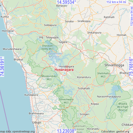
Hosanagara GPS coordinates[2]
13° 54' 49.932" North, 75° 3' 54.108" East
| Map corner | latitude | longitude |
|---|---|---|
| Upper-left | 14.59534°, | 74.36191° |
| Center: | 13.91387°, | 75.06503° |
| Lower-right: | 13.23038°, | 75.76816° |
| Map W x H: | 151.8×151.8 km | = 94.3×94.3mi |
| max Lat: | 34.9274° ⇑83.5% North |
| Hosanagara: | 13.91387° |
| min Lat: | ⇓16.5% South 8.09008° |
| min Long | Hosanagara | max Long |
| 68.82655° | 75.06503° | 96.81° |
| W 17.8%⇐ | ⇒82.2% E |
Elevation
Elevation of Hosanagara is 589 m = 1932 ft, and this is 293.4 m = 963 ft above average elevation for this country.
| Max E: |
3681 m = 12077 ft | 12.3% |
| Hosanagara | 589 m 1932 ft | |
| Avg. | 295.6 m = 970 ft | |
Min E: |
1 m = 3 ft | 87.7% |
See also: India elevation on elevation.city.
Geographical zone
Hosanagara is located in North Torrid zone (between Equator and Tropic of Cancer). Distance of this Northern Tropic circle is 1058.8 km =657.9 mi to North.| Distance of | km | miles | from Hosanagara |
|---|---|---|---|
| North Pole | 8460 | 5256.8 | to North |
| Arctic Circle | 5854.1 | 3637.6 | to North |
| Tropic Cancer | 1058.8 | 657.9 | to North |
| Equator | 1547.1 | 961.3 | to South |


Nearby cities:
15 places around Hosanagara: (largest is in red/bold)
• Beltangadi
26.5 km =16.5 mi,  73°
73°
• Bhatkal
55.6 km =34.5 mi,  278°
278°
• Byndoor
46.9 km =29.1 mi,  263°
263°
• Coondapoor
51.2 km =31.8 mi,  232°
232°
• Gangolli
51.7 km =32.1 mi,  235°
235°
• Hosangadi
26.9 km =16.7 mi,  206°
206°
• Koppa
53.4 km =33.2 mi,  142°
142°
• Kumsi
39.4 km =24.5 mi, 66°
• Shikārpur
50.5 km =31.4 mi,  38°
38°
• Shimoga
54.3 km =33.7 mi,  87°
87°
• Siddāpur
51.2 km =31.8 mi,  338°
338°
• Someshwar
47 km =29.2 mi,  179°
179°
• Sorab
52.1 km =32.4 mi,  3°
3°
• Sāgar
28.2 km =17.5 mi,  352°
352°
• Tīrthahalli
31.8 km =19.8 mi, 142°
Sources, notices
• [Note1] Compared only with cities in India existing in our database
• [Src1] Map data: © OpenStreetMap contributors (CC-BY-SA)
• [Src2] Other city data from geonames.org with taken over terms of usage.
• [Src3] Geographical zone / Annual Mean Temperature by Robert A. Rohde @ Wikipedia
