Gautampura geodata
Gautampura (Madhya Pradesh) is a populated place; located in India in Asia/Kolkata (GMT+5.5) time zone. With population of 14,562 people, there are 2505 cities with bigger population in this country. Compared to other cities in India, 51.5% of cities are located further ↓South; 78.4% of cities are located further →East and 82.6% of cities have lower elevation than Gautampura. Note1


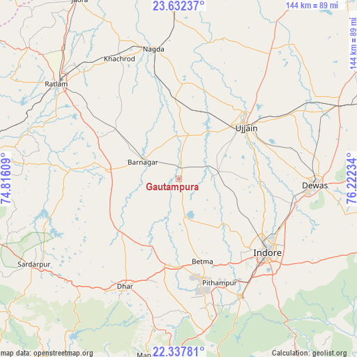
Gautampura GPS coordinates[2]
22° 59' 11.904" North, 75° 31' 9.156" East
| Map corner | latitude | longitude |
|---|---|---|
| Upper-left | 23.63237°, | 74.81609° |
| Center: | 22.98664°, | 75.51921° |
| Lower-right: | 22.33781°, | 76.22234° |
| Map W x H: | 143.9×143.9 km | = 89.4×89.4mi |
| max Lat: | 34.9274° ⇑48.5% North |
| Gautampura: | 22.98664° |
| min Lat: | ⇓51.5% South 8.09008° |
| min Long | Gautampura | max Long |
| 68.82655° | 75.51921° | 96.81° |
| W 21.6%⇐ | ⇒78.4% E |
Elevation
Elevation of Gautampura is 502 m = 1647 ft, and this is 206.4 m = 677 ft above average elevation for this country.
| Max E: |
3681 m = 12077 ft | 17.4% |
| Gautampura | 502 m 1647 ft | |
| Avg. | 295.6 m = 970 ft | |
Min E: |
1 m = 3 ft | 82.6% |
See also: India elevation on elevation.city.
Geographical zone
Gautampura is located in North Torrid zone (between Equator and Tropic of Cancer). Distance of this Northern Tropic circle is 50 km =31.1 mi to North.| Distance of | km | miles | from Gautampura |
|---|---|---|---|
| North Pole | 7451.2 | 4630 | to North |
| Arctic Circle | 4845.3 | 3010.7 | to North |
| Tropic Cancer | 50 | 31.1 | to North |
| Equator | 2555.9 | 1588.2 | to South |


Nearby cities:
15 places around Gautampura: (largest is in red/bold)
• Badnāwar
29.6 km =18.4 mi,  277°
277°
• Betma
34.8 km =21.6 mi,  163°
163°
• Depālpur
15.3 km =9.5 mi,  171°
171°
• Dewas
54.9 km =34.1 mi,  92°
92°
• Dhār
49.2 km =30.6 mi,  207°
207°
• Hātod
31.1 km =19.3 mi,  133°
133°
• Indore
43.9 km =27.3 mi, 132°
• Khāchrod
54.3 km =33.7 mi,  333°
333°
• Nagda
53.5 km =33.2 mi,  348°
348°
• Piploda
41.3 km =25.7 mi, 347°
• Pithampur
46.5 km =28.9 mi, 156°
• Ratlām
62.1 km =38.6 mi,  307°
307°
• Sānwer
31.5 km =19.6 mi, 92°
• Ujjain
34.1 km =21.2 mi,  50°
50°
• Unhel
39.3 km =24.4 mi,  5°
5°
Sources, notices
• [Note1] Compared only with cities in India existing in our database
• [Src1] Map data: © OpenStreetMap contributors (CC-BY-SA)
• [Src2] Other city data from geonames.org with taken over terms of usage.
• [Src3] Geographical zone / Annual Mean Temperature by Robert A. Rohde @ Wikipedia
