Dewas geodata
Dewas (Madhya Pradesh) is a populated place; located in India in Asia/Kolkata (GMT+5.5) time zone. With population of 261,218 people, there are 162 cities with bigger population in this country. Compared to other cities in India, 51.3% of cities are located further ↓South; 73.1% of cities are located further →East and 84.6% of cities have lower elevation than Dewas. Note1


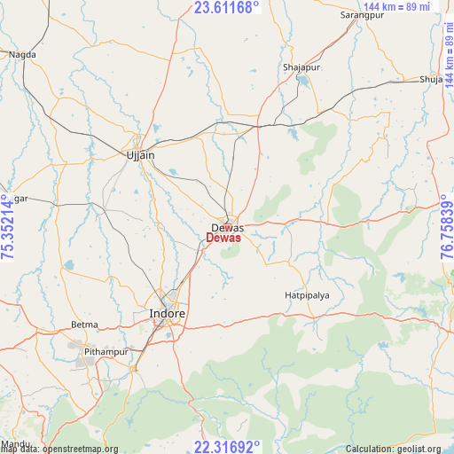
Dewas GPS coordinates[2]
22° 57' 57.06" North, 76° 3' 18.936" East
| Map corner | latitude | longitude |
|---|---|---|
| Upper-left | 23.61168°, | 75.35214° |
| Center: | 22.96585°, | 76.05526° |
| Lower-right: | 22.31692°, | 76.75839° |
| Map W x H: | 144×144 km | = 89.5×89.5mi |
| max Lat: | 34.9274° ⇑48.7% North |
| Dewas: | 22.96585° |
| min Lat: | ⇓51.3% South 8.09008° |
| min Long | Dewas | max Long |
| 68.82655° | 76.05526° | 96.81° |
| W 26.9%⇐ | ⇒73.1% E |
Elevation
Elevation of Dewas is 544 m = 1785 ft, and this is 248.4 m = 815 ft above average elevation for this country.
| Max E: |
3681 m = 12077 ft | 15.4% |
| Dewas | 544 m 1785 ft | |
| Avg. | 295.6 m = 970 ft | |
Min E: |
1 m = 3 ft | 84.6% |
See also: Dewas elevation on elevation.city.
Geographical zone
Dewas is located in North Torrid zone (between Equator and Tropic of Cancer). Distance of this Northern Tropic circle is 52.4 km =32.6 mi to North.| Distance of | km | miles | from Dewas |
|---|---|---|---|
| North Pole | 7453.5 | 4631.4 | to North |
| Arctic Circle | 4847.6 | 3012.2 | to North |
| Tropic Cancer | 52.4 | 32.6 | to North |
| Equator | 2553.6 | 1586.7 | to South |


Nearby cities:
15 places around Dewas: (largest is in red/bold)
• Betma
54.8 km =34.1 mi,  235°
235°
• Bāgli
47 km =29.2 mi,  140°
140°
• Depālpur
54.1 km =33.6 mi,  256°
256°
• Gautampura
54.9 km =34.1 mi,  272°
272°
• Hātod
37.6 km =23.4 mi, 239°
• Iklehra
39.8 km =24.7 mi,  59°
59°
• Indore
35.7 km =22.2 mi,  219°
219°
• Iāwar
45.9 km =28.5 mi,  83°
83°
• Maksi
34 km =21.1 mi,  15°
15°
• Pithampur
54.7 km =34 mi, 222°
• Shājāpur
56 km =34.8 mi, 23°
• Sānwer
23.4 km =14.5 mi, 272°
• Tarāna
40.9 km =25.4 mi,  358°
358°
• Ujjain
37.3 km =23.2 mi,  310°
310°
• Unhel
65.4 km =40.6 mi, 309°
Sources, notices
• [Note1] Compared only with cities in India existing in our database
• [Src1] Map data: © OpenStreetMap contributors (CC-BY-SA)
• [Src2] Other city data from geonames.org with taken over terms of usage.
• [Src3] Geographical zone / Annual Mean Temperature by Robert A. Rohde @ Wikipedia
