Depālpur geodata
Depālpur (Madhya Pradesh) is a populated place; located in India in Asia/Kolkata (GMT+5.5) time zone. With population of 16,936 people, there are 2292 cities with bigger population in this country. Compared to other cities in India, 50.5% of cities are located further ↓South; 78.2% of cities are located further →East and 84.3% of cities have lower elevation than Depālpur. Note1


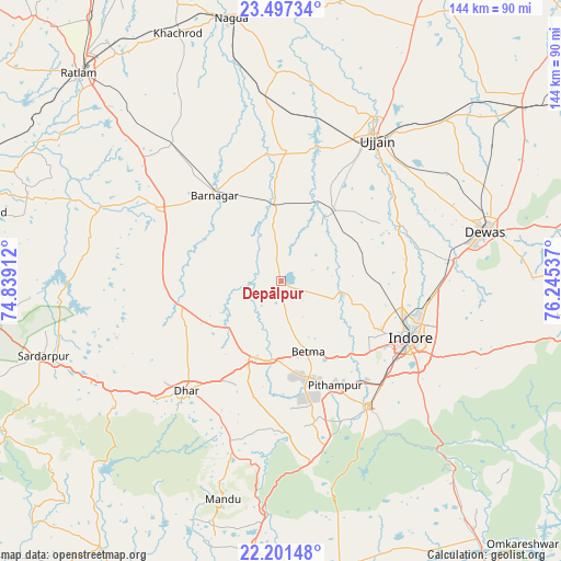
Depālpur GPS coordinates[2]
22° 51' 3.42" North, 75° 32' 32.064" East
| Map corner | latitude | longitude |
|---|---|---|
| Upper-left | 23.49734°, | 74.83912° |
| Center: | 22.85095°, | 75.54224° |
| Lower-right: | 22.20148°, | 76.24537° |
| Map W x H: | 144.1×144.1 km | = 89.5×89.5mi |
| max Lat: | 34.9274° ⇑49.5% North |
| Depālpur: | 22.85095° |
| min Lat: | ⇓50.5% South 8.09008° |
| min Long | Depālpur | max Long |
| 68.82655° | 75.54224° | 96.81° |
| W 21.8%⇐ | ⇒78.2% E |
Elevation
Elevation of Depālpur is 537 m = 1762 ft, and this is 241.4 m = 792 ft above average elevation for this country.
| Max E: |
3681 m = 12077 ft | 15.7% |
| Depālpur | 537 m 1762 ft | |
| Avg. | 295.6 m = 970 ft | |
Min E: |
1 m = 3 ft | 84.3% |
See also: India elevation on elevation.city.
Geographical zone
Depālpur is located in North Torrid zone (between Equator and Tropic of Cancer). Distance of this Northern Tropic circle is 65.1 km =40.5 mi to North.| Distance of | km | miles | from Depālpur |
|---|---|---|---|
| North Pole | 7466.3 | 4639.3 | to North |
| Arctic Circle | 4860.4 | 3020.1 | to North |
| Tropic Cancer | 65.1 | 40.5 | to North |
| Equator | 2540.8 | 1578.8 | to South |


Nearby cities:
15 places around Depālpur: (largest is in red/bold)
• Badnāwar
37 km =23 mi,  300°
300°
• Betma
19.7 km =12.2 mi,  157°
157°
• Dewas
54.1 km =33.6 mi,  76°
76°
• Dhār
38 km =23.6 mi,  221°
221°
• Gautampura
15.3 km =9.5 mi,  351°
351°
• Hātod
21.2 km =13.2 mi,  107°
107°
• Indore
33.3 km =20.7 mi,  116°
116°
• Mānpur
47.3 km =29.4 mi,  170°
170°
• Nagda
68.7 km =42.7 mi, 349°
• Piploda
56.6 km =35.2 mi, 348°
• Pithampur
31.9 km =19.8 mi,  150°
150°
• Rājgarh
64.2 km =39.9 mi,  252°
252°
• Sānwer
32.2 km =20 mi,  64°
64°
• Ujjain
44 km =27.3 mi,  33°
33°
• Unhel
54.2 km =33.7 mi,  1°
1°
Sources, notices
• [Note1] Compared only with cities in India existing in our database
• [Src1] Map data: © OpenStreetMap contributors (CC-BY-SA)
• [Src2] Other city data from geonames.org with taken over terms of usage.
• [Src3] Geographical zone / Annual Mean Temperature by Robert A. Rohde @ Wikipedia
