Hātod geodata
Hātod (Madhya Pradesh) is a populated place; located in India in Asia/Kolkata (GMT+5.5) time zone. With population of 9,349 people, there are 3007 cities with bigger population in this country. Compared to other cities in India, 50% of cities are located further ↓South; 76.3% of cities are located further →East and 84.4% of cities have lower elevation than Hātod. Note1


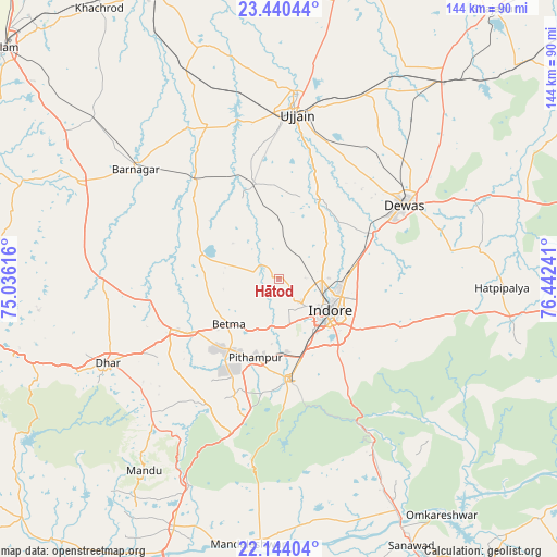
Hātod GPS coordinates[2]
22° 47' 37.608" North, 75° 44' 21.408" East
| Map corner | latitude | longitude |
|---|---|---|
| Upper-left | 23.44044°, | 75.03616° |
| Center: | 22.79378°, | 75.73928° |
| Lower-right: | 22.14404°, | 76.44241° |
| Map W x H: | 144.1×144.1 km | = 89.5×89.5mi |
| max Lat: | 34.9274° ⇑50% North |
| Hātod: | 22.79378° |
| min Lat: | ⇓50% South 8.09008° |
| min Long | Hātod | max Long |
| 68.82655° | 75.73928° | 96.81° |
| W 23.7%⇐ | ⇒76.3% E |
Elevation
Elevation of Hātod is 540 m = 1772 ft, and this is 244.4 m = 802 ft above average elevation for this country.
| Max E: |
3681 m = 12077 ft | 15.6% |
| Hātod | 540 m 1772 ft | |
| Avg. | 295.6 m = 970 ft | |
Min E: |
1 m = 3 ft | 84.4% |
See also: India elevation on elevation.city.
Geographical zone
Hātod is located in North Torrid zone (between Equator and Tropic of Cancer). Distance of this Northern Tropic circle is 71.5 km =44.4 mi to North.| Distance of | km | miles | from Hātod |
|---|---|---|---|
| North Pole | 7472.6 | 4643.3 | to North |
| Arctic Circle | 4866.7 | 3024 | to North |
| Tropic Cancer | 71.5 | 44.4 | to North |
| Equator | 2534.4 | 1574.8 | to South |


Nearby cities:
15 places around Hātod: (largest is in red/bold)
• Badnāwar
57.7 km =35.9 mi,  296°
296°
• Betma
17.5 km =10.9 mi,  227°
227°
• Bāgli
64.8 km =40.3 mi,  105°
105°
• Depālpur
21.2 km =13.2 mi,  287°
287°
• Dewas
37.6 km =23.4 mi,  59°
59°
• Dhār
50.5 km =31.4 mi,  243°
243°
• Gautampura
31.1 km =19.3 mi,  313°
313°
• Indore
12.8 km =8 mi,  131°
131°
• Maksi
66.5 km =41.3 mi,  38°
38°
• Mānpur
42.1 km =26.2 mi,  196°
196°
• Pithampur
21.8 km =13.5 mi,  191°
191°
• Sānwer
22 km =13.7 mi,  24°
24°
• Tarāna
67.6 km =42 mi,  27°
27°
• Ujjain
43.4 km =27 mi,  5°
5°
• Unhel
63.2 km =39.3 mi,  343°
343°
Sources, notices
• [Note1] Compared only with cities in India existing in our database
• [Src1] Map data: © OpenStreetMap contributors (CC-BY-SA)
• [Src2] Other city data from geonames.org with taken over terms of usage.
• [Src3] Geographical zone / Annual Mean Temperature by Robert A. Rohde @ Wikipedia
