Lal Bahadur Nagar geodata
Lal Bahadur Nagar (Telangana) is a populated place; located in India in Asia/Kolkata (GMT+5.5) time zone. With population of 261,987 people, there are 161 cities with bigger population in this country. Compared to other cities in India, 73.9% of cities are located further ↑North; 54.7% of cities are located further ←West and 83.2% of cities have lower elevation than Lal Bahadur Nagar. Note1


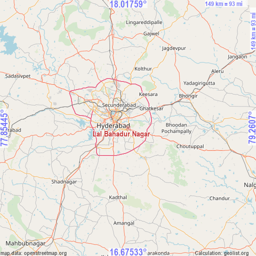
Lal Bahadur Nagar GPS coordinates[2]
17° 20' 51.684" North, 78° 33' 27.252" East
| Map corner | latitude | longitude |
|---|---|---|
| Upper-left | 18.01759°, | 77.85445° |
| Center: | 17.34769°, | 78.55757° |
| Lower-right: | 16.67533°, | 79.2607° |
| Map W x H: | 149.2×149.2 km | = 92.7×92.7mi |
| max Lat: | 34.9274° ⇑73.9% North |
| Lal Bahadur Nagar: | 17.34769° |
| min Lat: | ⇓26.1% South 8.09008° |
| min Long | Lal Bahadur Nag | max Long |
| 68.82655° | 78.55757° | 96.81° |
| W 54.7%⇐ | ⇒45.3% E |
Elevation
Elevation of Lal Bahadur Nagar is 511 m = 1677 ft, and this is 215.4 m = 707 ft above average elevation for this country.
| Max E: |
3681 m = 12077 ft | 16.8% |
| Lal Bahadur Nagar | 511 m 1677 ft | |
| Avg. | 295.6 m = 970 ft | |
Min E: |
1 m = 3 ft | 83.2% |
See also: Lal Bahadur Nagar elevation on elevation.city.
Geographical zone
Lal Bahadur Nagar is located in North Torrid zone (between Equator and Tropic of Cancer). Distance of this Northern Tropic circle is 677 km =420.7 mi to North.| Distance of | km | miles | from Lal Bahadur Nagar |
|---|---|---|---|
| North Pole | 8078.2 | 5019.6 | to North |
| Arctic Circle | 5472.3 | 3400.3 | to North |
| Tropic Cancer | 677 | 420.7 | to North |
| Equator | 1928.9 | 1198.6 | to South |


Nearby cities:
15 places around Lal Bahadur Nagar: (largest is in red/bold)
• Bhongīr
39.5 km =24.5 mi,  61°
61°
• Bālāpur
7.4 km =4.6 mi,  235°
235°
• Gaddi Annaram
4.1 km =2.5 mi,  301°
301°
• Ghatkesar
17.6 km =10.9 mi,  49°
49°
• Gūdūr
32.4 km =20.1 mi, 60°
• Hyderabad
11.5 km =7.1 mi,  290°
290°
• Kūkatpalli
21.6 km =13.4 mi,  314°
314°
• Malkajgiri
11.6 km =7.2 mi,  343°
343°
• Medchal
32.4 km =20.1 mi,  345°
345°
• Patancheru
37.3 km =23.2 mi, 303°
• Quthbullapur
20.1 km =12.5 mi,  328°
328°
• Secunderabad
17.5 km =10.9 mi, 354°
• Serilingampalle
31.6 km =19.6 mi, 300°
• Srīrāmnagar
33.3 km =20.7 mi,  254°
254°
• Uppal Kalan
6.5 km =4 mi,  1°
1°
Sources, notices
• [Note1] Compared only with cities in India existing in our database
• [Src1] Map data: © OpenStreetMap contributors (CC-BY-SA)
• [Src2] Other city data from geonames.org with taken over terms of usage.
• [Src3] Geographical zone / Annual Mean Temperature by Robert A. Rohde @ Wikipedia
