Patancheru geodata
Patancheru (Telangana) is a populated place; located in India in Asia/Kolkata (GMT+5.5) time zone. With population of 46,821 people, there are 943 cities with bigger population in this country. Compared to other cities in India, 73.2% of cities are located further ↑North; 51.9% of cities are located further ←West and 84.4% of cities have lower elevation than Patancheru. Note1


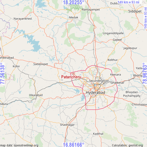
Patancheru GPS coordinates[2]
17° 32' 0.024" North, 78° 15' 52.2" East
| Map corner | latitude | longitude |
|---|---|---|
| Upper-left | 18.20255°, | 77.56138° |
| Center: | 17.53334°, | 78.2645° |
| Lower-right: | 16.86166°, | 78.96763° |
| Map W x H: | 149.1×149.1 km | = 92.6×92.6mi |
| max Lat: | 34.9274° ⇑73.2% North |
| Patancheru: | 17.53334° |
| min Lat: | ⇓26.8% South 8.09008° |
| min Long | Patancheru | max Long |
| 68.82655° | 78.2645° | 96.81° |
| W 51.9%⇐ | ⇒48.1% E |
Elevation
Elevation of Patancheru is 540 m = 1772 ft, and this is 244.4 m = 802 ft above average elevation for this country.
| Max E: |
3681 m = 12077 ft | 15.6% |
| Patancheru | 540 m 1772 ft | |
| Avg. | 295.6 m = 970 ft | |
Min E: |
1 m = 3 ft | 84.4% |
See also: Patancheru elevation on elevation.city.
Geographical zone
Patancheru is located in North Torrid zone (between Equator and Tropic of Cancer). Distance of this Northern Tropic circle is 656.4 km =407.9 mi to North.| Distance of | km | miles | from Patancheru |
|---|---|---|---|
| North Pole | 8057.5 | 5006.7 | to North |
| Arctic Circle | 5451.6 | 3387.5 | to North |
| Tropic Cancer | 656.4 | 407.9 | to North |
| Equator | 1949.5 | 1211.4 | to South |


Nearby cities:
15 places around Patancheru: (largest is in red/bold)
• Andol
37 km =23 mi,  327°
327°
• Bālāpur
35.2 km =21.9 mi,  134°
134°
• Gaddi Annaram
33.2 km =20.6 mi,  123°
123°
• Hyderabad
26.3 km =16.3 mi, 129°
• Kūkatpalli
16.7 km =10.4 mi,  108°
108°
• Malkajgiri
29.4 km =18.3 mi, 108°
• Medchal
25.4 km =15.8 mi,  65°
65°
• Quthbullapur
20.8 km =12.9 mi,  99°
99°
• Sadāseopet
34.4 km =21.4 mi,  286°
286°
• Sangāreddi
21.4 km =13.3 mi,  298°
298°
• Secunderabad
29.7 km =18.5 mi, 96°
• Serilingampalle
6 km =3.7 mi,  138°
138°
• Singāpur
16.3 km =10.1 mi,  244°
244°
• Srīrāmnagar
29.7 km =18.5 mi,  181°
181°
• Uppal Kalan
34.3 km =21.3 mi, 114°
Sources, notices
• [Note1] Compared only with cities in India existing in our database
• [Src1] Map data: © OpenStreetMap contributors (CC-BY-SA)
• [Src2] Other city data from geonames.org with taken over terms of usage.
• [Src3] Geographical zone / Annual Mean Temperature by Robert A. Rohde @ Wikipedia
