Secunderabad geodata
Secunderabad (Telangana) is a populated place; located in India in Asia/Kolkata (GMT+5.5) time zone. With population of 204,182 people, there are 203 cities with bigger population in this country. Compared to other cities in India, 73.3% of cities are located further ↑North; 54.6% of cities are located further ←West and 86.3% of cities have lower elevation than Secunderabad. Note1


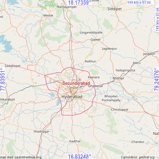
Secunderabad GPS coordinates[2]
17° 30' 15.372" North, 78° 32' 33.468" East
| Map corner | latitude | longitude |
|---|---|---|
| Upper-left | 18.17359°, | 77.83951° |
| Center: | 17.50427°, | 78.54263° |
| Lower-right: | 16.83248°, | 79.24576° |
| Map W x H: | 149.1×149.1 km | = 92.6×92.6mi |
| max Lat: | 34.9274° ⇑73.3% North |
| Secunderabad: | 17.50427° |
| min Lat: | ⇓26.7% South 8.09008° |
| min Long | Secunderabad | max Long |
| 68.82655° | 78.54263° | 96.81° |
| W 54.6%⇐ | ⇒45.4% E |
Elevation
Elevation of Secunderabad is 566 m = 1857 ft, and this is 270.4 m = 887 ft above average elevation for this country.
| Max E: |
3681 m = 12077 ft | 13.7% |
| Secunderabad | 566 m 1857 ft | |
| Avg. | 295.6 m = 970 ft | |
Min E: |
1 m = 3 ft | 86.3% |
See also: Secunderabad elevation on elevation.city.
Geographical zone
Secunderabad is located in North Torrid zone (between Equator and Tropic of Cancer). Distance of this Northern Tropic circle is 659.6 km =409.9 mi to North.| Distance of | km | miles | from Secunderabad |
|---|---|---|---|
| North Pole | 8060.8 | 5008.7 | to North |
| Arctic Circle | 5454.9 | 3389.5 | to North |
| Tropic Cancer | 659.6 | 409.9 | to North |
| Equator | 1946.3 | 1209.4 | to South |


Nearby cities:
15 places around Secunderabad: (largest is in red/bold)
• Bhongīr
36.4 km =22.6 mi,  88°
88°
• Bālāpur
22.1 km =13.7 mi,  191°
191°
• Gaddi Annaram
15.4 km =9.6 mi, 187°
• Ghatkesar
16.1 km =10 mi,  111°
111°
• Gūdūr
29.8 km =18.5 mi, 92°
• Hyderabad
16.2 km =10.1 mi,  214°
214°
• Kūkatpalli
13.8 km =8.6 mi,  261°
261°
• Lal Bahadur Nagar
17.5 km =10.9 mi,  174°
174°
• Malkajgiri
6.5 km =4 mi,  195°
195°
• Medchal
15.4 km =9.6 mi,  335°
335°
• Patancheru
29.7 km =18.5 mi,  276°
276°
• Quthbullapur
9 km =5.6 mi,  267°
267°
• Serilingampalle
25.6 km =15.9 mi, 267°
• Srīrāmnagar
40.3 km =25 mi,  229°
229°
• Uppal Kalan
11.1 km =6.9 mi, 170°
Sources, notices
• [Note1] Compared only with cities in India existing in our database
• [Src1] Map data: © OpenStreetMap contributors (CC-BY-SA)
• [Src2] Other city data from geonames.org with taken over terms of usage.
• [Src3] Geographical zone / Annual Mean Temperature by Robert A. Rohde @ Wikipedia
