Uppal Kalan geodata
Uppal Kalan (Telangana) is a populated place; located in India in Asia/Kolkata (GMT+5.5) time zone. With population of 118,259 people, there are 373 cities with bigger population in this country. Compared to other cities in India, 73.7% of cities are located further ↑North; 54.8% of cities are located further ←West and 82.6% of cities have lower elevation than Uppal Kalan. Note1


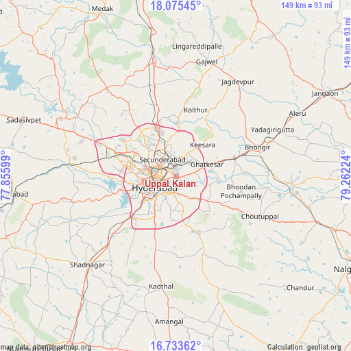
Uppal Kalan GPS coordinates[2]
17° 24' 20.772" North, 78° 33' 32.796" East
| Map corner | latitude | longitude |
|---|---|---|
| Upper-left | 18.07545°, | 77.85599° |
| Center: | 17.40577°, | 78.55911° |
| Lower-right: | 16.73362°, | 79.26224° |
| Map W x H: | 149.2×149.2 km | = 92.7×92.7mi |
| max Lat: | 34.9274° ⇑73.7% North |
| Uppal Kalan: | 17.40577° |
| min Lat: | ⇓26.3% South 8.09008° |
| min Long | Uppal Kalan | max Long |
| 68.82655° | 78.55911° | 96.81° |
| W 54.8%⇐ | ⇒45.2% E |
Elevation
Elevation of Uppal Kalan is 502 m = 1647 ft, and this is 206.4 m = 677 ft above average elevation for this country.
| Max E: |
3681 m = 12077 ft | 17.4% |
| Uppal Kalan | 502 m 1647 ft | |
| Avg. | 295.6 m = 970 ft | |
Min E: |
1 m = 3 ft | 82.6% |
See also: Uppal Kalan elevation on elevation.city.
Geographical zone
Uppal Kalan is located in North Torrid zone (between Equator and Tropic of Cancer). Distance of this Northern Tropic circle is 670.6 km =416.7 mi to North.| Distance of | km | miles | from Uppal Kalan |
|---|---|---|---|
| North Pole | 8071.7 | 5015.5 | to North |
| Arctic Circle | 5465.8 | 3396.3 | to North |
| Tropic Cancer | 670.6 | 416.7 | to North |
| Equator | 1935.3 | 1202.5 | to South |


Nearby cities:
15 places around Uppal Kalan: (largest is in red/bold)
• Bhongīr
36.7 km =22.8 mi,  70°
70°
• Bālāpur
12.4 km =7.7 mi,  210°
210°
• Gaddi Annaram
5.7 km =3.5 mi,  220°
220°
• Ghatkesar
14.1 km =8.8 mi, 69°
• Gūdūr
29.6 km =18.4 mi, 71°
• Hyderabad
11.2 km =7 mi,  257°
257°
• Kūkatpalli
17.7 km =11 mi,  299°
299°
• Lal Bahadur Nagar
6.5 km =4 mi,  181°
181°
• Malkajgiri
5.8 km =3.6 mi,  323°
323°
• Medchal
26.2 km =16.3 mi,  341°
341°
• Patancheru
34.3 km =21.3 mi,  294°
294°
• Quthbullapur
15.1 km =9.4 mi,  314°
314°
• Secunderabad
11.1 km =6.9 mi,  350°
350°
• Serilingampalle
29 km =18 mi, 289°
• Srīrāmnagar
35.8 km =22.2 mi,  244°
244°
Sources, notices
• [Note1] Compared only with cities in India existing in our database
• [Src1] Map data: © OpenStreetMap contributors (CC-BY-SA)
• [Src2] Other city data from geonames.org with taken over terms of usage.
• [Src3] Geographical zone / Annual Mean Temperature by Robert A. Rohde @ Wikipedia
