Medchal geodata
Medchal (Telangana) is a seat of a second-order administrative division; located in India in Asia/Kolkata (GMT+5.5) time zone. In our database, there are 3475 cities with bigger population. Compared to other cities in India, 72.7% of cities are located further ↑North; 54% of cities are located further ←West and 87.9% of cities have lower elevation than Medchal. Note1


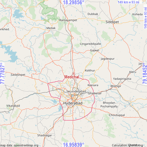
Medchal GPS coordinates[2]
17° 37' 46.992" North, 78° 28' 53.004" East
| Map corner | latitude | longitude |
|---|---|---|
| Upper-left | 18.29856°, | 77.77827° |
| Center: | 17.62972°, | 78.48139° |
| Lower-right: | 16.95839°, | 79.18452° |
| Map W x H: | 149×149 km | = 92.6×92.6mi |
| max Lat: | 34.9274° ⇑72.7% North |
| Medchal: | 17.62972° |
| min Lat: | ⇓27.3% South 8.09008° |
| min Long | Medchal | max Long |
| 68.82655° | 78.48139° | 96.81° |
| W 54%⇐ | ⇒46% E |
Elevation
Elevation of Medchal is 591 m = 1939 ft, and this is 295.4 m = 969 ft above average elevation for this country.
| Max E: |
3681 m = 12077 ft | 12.1% |
| Medchal | 591 m 1939 ft | |
| Avg. | 295.6 m = 970 ft | |
Min E: |
1 m = 3 ft | 87.9% |
See also: India elevation on elevation.city.
Geographical zone
Medchal is located in North Torrid zone (between Equator and Tropic of Cancer). Distance of this Northern Tropic circle is 645.7 km =401.2 mi to North.| Distance of | km | miles | from Medchal |
|---|---|---|---|
| North Pole | 8046.8 | 5000 | to North |
| Arctic Circle | 5440.9 | 3380.8 | to North |
| Tropic Cancer | 645.7 | 401.2 | to North |
| Equator | 1960.2 | 1218 | to South |


Nearby cities:
15 places around Medchal: (largest is in red/bold)
• Bālāpur
35.6 km =22.1 mi,  176°
176°
• Gaddi Annaram
29.6 km =18.4 mi,  171°
171°
• Ghatkesar
29.3 km =18.2 mi,  132°
132°
• Gūdūr
39.3 km =24.4 mi,  112°
112°
• Hyderabad
27.4 km =17 mi,  185°
185°
• Kūkatpalli
17.6 km =10.9 mi,  203°
203°
• Lal Bahadur Nagar
32.4 km =20.1 mi, 165°
• Malkajgiri
20.8 km =12.9 mi, 166°
• Patancheru
25.4 km =15.8 mi,  245°
245°
• Quthbullapur
14.5 km =9 mi, 189°
• Sangāreddi
41.8 km =26 mi,  269°
269°
• Secunderabad
15.4 km =9.6 mi,  155°
155°
• Serilingampalle
24.3 km =15.1 mi,  231°
231°
• Singāpur
41.7 km =25.9 mi,  244°
244°
• Uppal Kalan
26.2 km =16.3 mi, 161°
Sources, notices
• [Note1] Compared only with cities in India existing in our database
• [Src1] Map data: © OpenStreetMap contributors (CC-BY-SA)
• [Src2] Other city data from geonames.org with taken over terms of usage.
• [Src3] Geographical zone / Annual Mean Temperature by Robert A. Rohde @ Wikipedia
