Quthbullapur geodata
Quthbullapur (Telangana) is a populated place; located in India in Asia/Kolkata (GMT+5.5) time zone. With population of 225,816 people, there are 189 cities with bigger population in this country. Compared to other cities in India, 73.3% of cities are located further ↑North; 53.8% of cities are located further ←West and 85.3% of cities have lower elevation than Quthbullapur. Note1


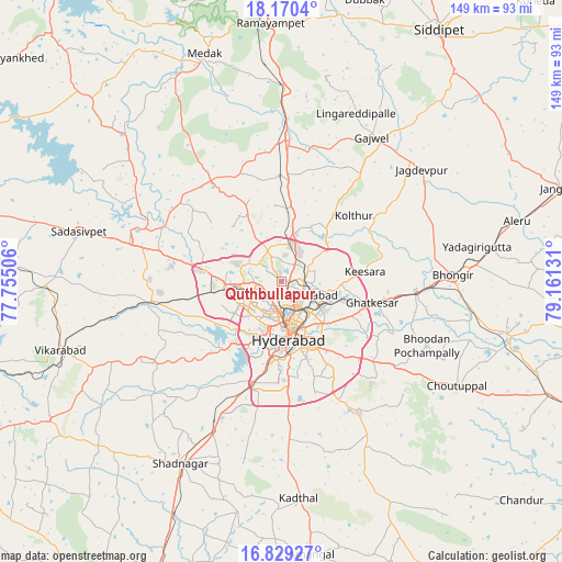
Quthbullapur GPS coordinates[2]
17° 30' 3.852" North, 78° 27' 29.448" East
| Map corner | latitude | longitude |
|---|---|---|
| Upper-left | 18.1704°, | 77.75506° |
| Center: | 17.50107°, | 78.45818° |
| Lower-right: | 16.82927°, | 79.16131° |
| Map W x H: | 149.1×149.1 km | = 92.6×92.6mi |
| max Lat: | 34.9274° ⇑73.3% North |
| Quthbullapur: | 17.50107° |
| min Lat: | ⇓26.7% South 8.09008° |
| min Long | Quthbullapur | max Long |
| 68.82655° | 78.45818° | 96.81° |
| W 53.8%⇐ | ⇒46.2% E |
Elevation
Elevation of Quthbullapur is 554 m = 1818 ft, and this is 258.4 m = 848 ft above average elevation for this country.
| Max E: |
3681 m = 12077 ft | 14.7% |
| Quthbullapur | 554 m 1818 ft | |
| Avg. | 295.6 m = 970 ft | |
Min E: |
1 m = 3 ft | 85.3% |
See also: Quthbullapur elevation on elevation.city.
Geographical zone
Quthbullapur is located in North Torrid zone (between Equator and Tropic of Cancer). Distance of this Northern Tropic circle is 660 km =410.1 mi to North.| Distance of | km | miles | from Quthbullapur |
|---|---|---|---|
| North Pole | 8061.1 | 5008.9 | to North |
| Arctic Circle | 5455.2 | 3389.7 | to North |
| Tropic Cancer | 660 | 410.1 | to North |
| Equator | 1945.9 | 1209.1 | to South |


Nearby cities:
15 places around Quthbullapur: (largest is in red/bold)
• Bālāpur
21.7 km =13.5 mi,  168°
168°
• Gaddi Annaram
16.5 km =10.3 mi,  154°
154°
• Ghatkesar
24.6 km =15.3 mi,  103°
103°
• Gūdūr
38.7 km =24 mi,  91°
91°
• Hyderabad
13 km =8.1 mi,  180°
180°
• Kūkatpalli
5 km =3.1 mi,  249°
249°
• Lal Bahadur Nagar
20.1 km =12.5 mi, 148°
• Malkajgiri
9.3 km =5.8 mi,  129°
129°
• Medchal
14.5 km =9 mi,  9°
9°
• Patancheru
20.8 km =12.9 mi,  279°
279°
• Secunderabad
9 km =5.6 mi, 87°
• Serilingampalle
16.6 km =10.3 mi,  266°
266°
• Singāpur
35.4 km =22 mi,  264°
264°
• Srīrāmnagar
33.8 km =21 mi,  219°
219°
• Uppal Kalan
15.1 km =9.4 mi, 134°
Sources, notices
• [Note1] Compared only with cities in India existing in our database
• [Src1] Map data: © OpenStreetMap contributors (CC-BY-SA)
• [Src2] Other city data from geonames.org with taken over terms of usage.
• [Src3] Geographical zone / Annual Mean Temperature by Robert A. Rohde @ Wikipedia
