Singāpur geodata
Singāpur (Telangana) is a populated place; located in India in Asia/Kolkata (GMT+5.5) time zone. With population of 24,457 people, there are 1739 cities with bigger population in this country. Compared to other cities in India, 73.5% of cities are located further ↑North; 50.2% of cities are located further ←West and 88.2% of cities have lower elevation than Singāpur. Note1


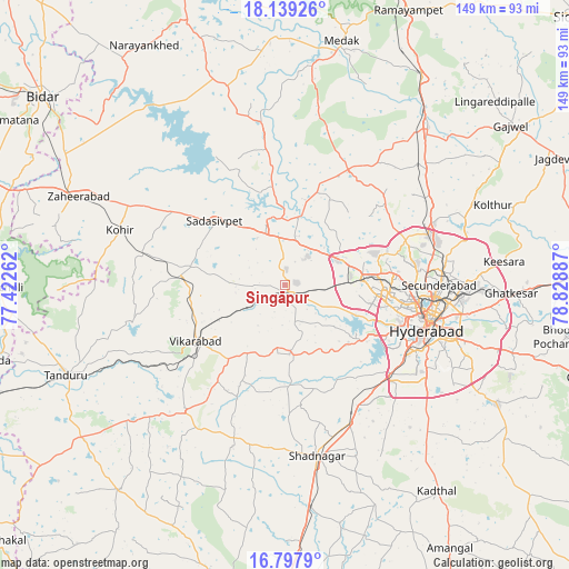
Singāpur GPS coordinates[2]
17° 28' 11.352" North, 78° 7' 32.664" East
| Map corner | latitude | longitude |
|---|---|---|
| Upper-left | 18.13926°, | 77.42262° |
| Center: | 17.46982°, | 78.12574° |
| Lower-right: | 16.7979°, | 78.82887° |
| Map W x H: | 149.1×149.1 km | = 92.6×92.6mi |
| max Lat: | 34.9274° ⇑73.5% North |
| Singāpur: | 17.46982° |
| min Lat: | ⇓26.5% South 8.09008° |
| min Long | Singāpur | max Long |
| 68.82655° | 78.12574° | 96.81° |
| W 50.2%⇐ | ⇒49.8% E |
Elevation
Elevation of Singāpur is 594 m = 1949 ft, and this is 298.4 m = 979 ft above average elevation for this country.
| Max E: |
3681 m = 12077 ft | 11.8% |
| Singāpur | 594 m 1949 ft | |
| Avg. | 295.6 m = 970 ft | |
Min E: |
1 m = 3 ft | 88.2% |
See also: India elevation on elevation.city.
Geographical zone
Singāpur is located in North Torrid zone (between Equator and Tropic of Cancer). Distance of this Northern Tropic circle is 663.5 km =412.3 mi to North.| Distance of | km | miles | from Singāpur |
|---|---|---|---|
| North Pole | 8064.6 | 5011.1 | to North |
| Arctic Circle | 5458.7 | 3391.9 | to North |
| Tropic Cancer | 663.5 | 412.3 | to North |
| Equator | 1942.5 | 1207 | to South |


Nearby cities:
15 places around Singāpur: (largest is in red/bold)
• Andol
38.7 km =24 mi,  352°
352°
• Bālāpur
43.5 km =27 mi,  114°
114°
• Gaddi Annaram
43.8 km =27.2 mi, 105°
• Hyderabad
36.3 km =22.6 mi, 105°
• Kūkatpalli
30.6 km =19 mi,  86°
86°
• Malkajgiri
42.6 km =26.5 mi, 93°
• Medchal
41.7 km =25.9 mi,  64°
64°
• Patancheru
16.3 km =10.1 mi, 64°
• Quthbullapur
35.4 km =22 mi,  84°
84°
• Sadāseopet
24.8 km =15.4 mi,  312°
312°
• Sangāreddi
17.7 km =11 mi, 346°
• Secunderabad
44.4 km =27.6 mi, 85°
• Serilingampalle
18.9 km =11.7 mi, 82°
• Srīrāmnagar
26.5 km =16.5 mi,  148°
148°
• Vikārābād
27.7 km =17.2 mi,  238°
238°
Sources, notices
• [Note1] Compared only with cities in India existing in our database
• [Src1] Map data: © OpenStreetMap contributors (CC-BY-SA)
• [Src2] Other city data from geonames.org with taken over terms of usage.
• [Src3] Geographical zone / Annual Mean Temperature by Robert A. Rohde @ Wikipedia
