Ghātanji geodata
Ghātanji (Maharashtra) is a populated place; located in India in Asia/Kolkata (GMT+5.5) time zone. With population of 20,785 people, there are 1982 cities with bigger population in this country. Compared to other cities in India, 64.7% of cities are located further ↑North; 52.4% of cities are located further ←West and 64.5% of cities have lower elevation than Ghātanji. Note1


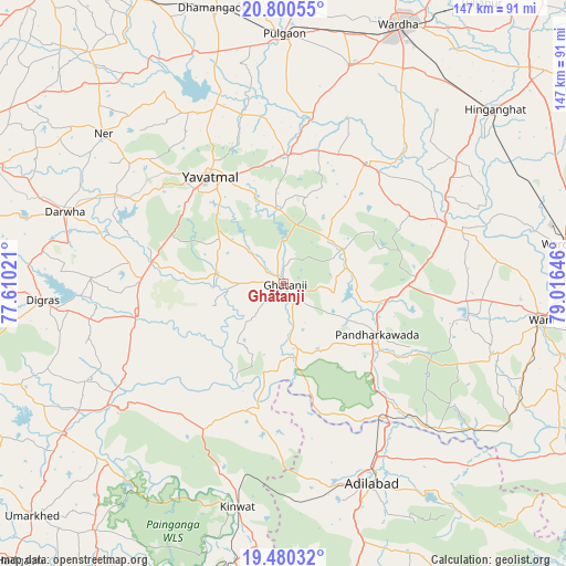
Ghātanji GPS coordinates[2]
20° 8' 30.588" North, 78° 18' 47.988" East
| Map corner | latitude | longitude |
|---|---|---|
| Upper-left | 20.80055°, | 77.61021° |
| Center: | 20.14183°, | 78.31333° |
| Lower-right: | 19.48032°, | 79.01646° |
| Map W x H: | 146.8×146.8 km | = 91.2×91.2mi |
| max Lat: | 34.9274° ⇑64.7% North |
| Ghātanji: | 20.14183° |
| min Lat: | ⇓35.3% South 8.09008° |
| min Long | Ghātanji | max Long |
| 68.82655° | 78.31333° | 96.81° |
| W 52.4%⇐ | ⇒47.6% E |
Elevation
Elevation of Ghātanji is 282 m = 925 ft, and this is 13.6 m = 45 ft below average elevation for this country.
| Max E: |
3681 m = 12077 ft | 35.5% |
| Avg. | 295.6 m = 970 ft | |
| Ghātanji | 282 m = 925 ft | |
Min E: |
1 m = 3 ft | 64.5% |
See also: India elevation on elevation.city.
Geographical zone
Ghātanji is located in North Torrid zone (between Equator and Tropic of Cancer). Distance of this Northern Tropic circle is 366.4 km =227.7 mi to North.| Distance of | km | miles | from Ghātanji |
|---|---|---|---|
| North Pole | 7767.5 | 4826.5 | to North |
| Arctic Circle | 5161.6 | 3207.3 | to North |
| Tropic Cancer | 366.4 | 227.7 | to North |
| Equator | 2239.6 | 1391.6 | to South |


Nearby cities:
15 places around Ghātanji: (largest is in red/bold)
• Dasnapur
58.1 km =36.1 mi,  159°
159°
• Deoli
59 km =36.7 mi,  17°
17°
• Digras
62.3 km =38.7 mi,  266°
266°
• Dārwha
59.4 km =36.9 mi,  288°
288°
• Hinganghāt
71.1 km =44.2 mi,  50°
50°
• Kinwat
58.6 km =36.4 mi,  191°
191°
• Kyathampalle
57.3 km =35.6 mi, 156°
• Pulgaon
64.5 km =40.1 mi,  0°
0°
• Rājur
60.6 km =37.7 mi,  93°
93°
• Sonegaon
67 km =41.6 mi,  36°
36°
• Wani
67.5 km =41.9 mi,  98°
98°
• Wardha
72.7 km =45.2 mi, 24°
• Warora
72.6 km =45.1 mi,  82°
82°
• Yavatmāl
33.8 km =21 mi,  325°
325°
• Ādilābād
57.2 km =35.5 mi, 155°
Sources, notices
• [Note1] Compared only with cities in India existing in our database
• [Src1] Map data: © OpenStreetMap contributors (CC-BY-SA)
• [Src2] Other city data from geonames.org with taken over terms of usage.
• [Src3] Geographical zone / Annual Mean Temperature by Robert A. Rohde @ Wikipedia
