Pusad geodata
Pusad (Maharashtra) is a populated place; located in India in Asia/Kolkata (GMT+5.5) time zone. With population of 71,588 people, there are 609 cities with bigger population in this country. Compared to other cities in India, 65.5% of cities are located further ↑North; 56.3% of cities are located further →East and 70.9% of cities have lower elevation than Pusad. Note1


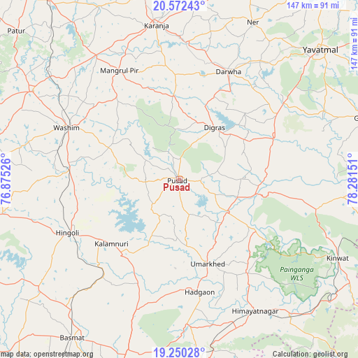
Pusad GPS coordinates[2]
19° 54' 45.864" North, 77° 34' 42.168" East
| Map corner | latitude | longitude |
|---|---|---|
| Upper-left | 20.57243°, | 76.87526° |
| Center: | 19.91274°, | 77.57838° |
| Lower-right: | 19.25028°, | 78.28151° |
| Map W x H: | 147×147 km | = 91.3×91.3mi |
| max Lat: | 34.9274° ⇑65.5% North |
| Pusad: | 19.91274° |
| min Lat: | ⇓34.5% South 8.09008° |
| min Long | Pusad | max Long |
| 68.82655° | 77.57838° | 96.81° |
| W 43.7%⇐ | ⇒56.3% E |
Elevation
Elevation of Pusad is 336 m = 1102 ft, and this is 40.4 m = 133 ft above average elevation for this country.
| Max E: |
3681 m = 12077 ft | 29.1% |
| Pusad | 336 m 1102 ft | |
| Avg. | 295.6 m = 970 ft | |
Min E: |
1 m = 3 ft | 70.9% |
See also: Pusad elevation on elevation.city.
Geographical zone
Pusad is located in North Torrid zone (between Equator and Tropic of Cancer). Distance of this Northern Tropic circle is 391.8 km =243.5 mi to North.| Distance of | km | miles | from Pusad |
|---|---|---|---|
| North Pole | 7793 | 4842.3 | to North |
| Arctic Circle | 5187.1 | 3223.1 | to North |
| Tropic Cancer | 391.8 | 243.5 | to North |
| Equator | 2214.1 | 1375.8 | to South |


Nearby cities:
15 places around Pusad: (largest is in red/bold)
• Anshing
31 km =19.3 mi,  297°
297°
• Basmat
78.5 km =48.8 mi,  214°
214°
• Digras
25.8 km =16 mi,  34°
34°
• Dārwha
48.6 km =30.2 mi,  24°
24°
• Ghātanji
80.9 km =50.3 mi,  71°
71°
• Hadgāon
47.1 km =29.3 mi,  169°
169°
• Hingoli
50.6 km =31.4 mi,  244°
244°
• Kalamnūri
38.5 km =23.9 mi,  226°
226°
• Kinwat
72.3 km =44.9 mi,  116°
116°
• Kāranja
64.1 km =39.8 mi,  351°
351°
• Mangrūl Pīr
51 km =31.7 mi,  331°
331°
• Risod
82.9 km =51.5 mi,  274°
274°
• Umarkhed
36.5 km =22.7 mi,  161°
161°
• Wāshīm
51.5 km =32 mi, 295°
• Yavatmāl
78.7 km =48.9 mi,  47°
47°
Sources, notices
• [Note1] Compared only with cities in India existing in our database
• [Src1] Map data: © OpenStreetMap contributors (CC-BY-SA)
• [Src2] Other city data from geonames.org with taken over terms of usage.
• [Src3] Geographical zone / Annual Mean Temperature by Robert A. Rohde @ Wikipedia
