Cheyyar geodata
Cheyyar (Tamil Nadu) is a populated place; located in India in Asia/Kolkata (GMT+5.5) time zone. With population of 36,527 people, there are 1200 cities with bigger population in this country. Compared to other cities in India, 88% of cities are located further ↑North; 64.2% of cities are located further ←West and 68.7% of cities have higher elevation than Cheyyar. Note1


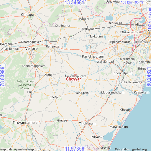
Cheyyar GPS coordinates[2]
12° 39' 37.872" North, 79° 32' 35.088" East
| Map corner | latitude | longitude |
|---|---|---|
| Upper-left | 13.34561°, | 78.83996° |
| Center: | 12.66052°, | 79.54308° |
| Lower-right: | 11.97358°, | 80.24621° |
| Map W x H: | 152.6×152.6 km | = 94.8×94.8mi |
| max Lat: | 34.9274° ⇑88% North |
| Cheyyar: | 12.66052° |
| min Lat: | ⇓12% South 8.09008° |
| min Long | Cheyyar | max Long |
| 68.82655° | 79.54308° | 96.81° |
| W 64.2%⇐ | ⇒35.8% E |
Elevation
Elevation of Cheyyar is 99 m = 325 ft, and this is 196.6 m = 645 ft below average elevation for this country.
| Max E: |
3681 m = 12077 ft | 68.7% |
| Avg. | 295.6 m = 970 ft | |
| Cheyyar | 99 m = 325 ft | |
Min E: |
1 m = 3 ft | 31.3% |
See also: India elevation on elevation.city.
Geographical zone
Cheyyar is located in North Torrid zone (between Equator and Tropic of Cancer). Distance of this Northern Tropic circle is 1198.2 km =744.5 mi to North.| Distance of | km | miles | from Cheyyar |
|---|---|---|---|
| North Pole | 8599.3 | 5343.4 | to North |
| Arctic Circle | 5993.5 | 3724.2 | to North |
| Tropic Cancer | 1198.2 | 744.5 | to North |
| Equator | 1407.7 | 874.7 | to South |


Nearby cities:
15 places around Cheyyar: (largest is in red/bold)
• Arcot
36.5 km =22.7 mi,  318°
318°
• Arni
28 km =17.4 mi,  271°
271°
• Chingleput
47.2 km =29.3 mi,  85°
85°
• Desūr
25.7 km =16 mi,  195°
195°
• Dūsi
19.5 km =12.1 mi,  48°
48°
• Gingee
47.3 km =29.4 mi, 196°
• Kalavai
18.1 km =11.2 mi,  312°
312°
• Kanchipuram
25.8 km =16 mi,  41°
41°
• Madurāntakam
40.6 km =25.2 mi,  114°
114°
• Nangilickondan
45.6 km =28.3 mi,  189°
189°
• Peranamallūr
15.6 km =9.7 mi,  229°
229°
• Uttiramerūr
23.8 km =14.8 mi,  102°
102°
• Vandavāsi
18.6 km =11.6 mi,  158°
158°
• Walajapet
35.1 km =21.8 mi,  326°
326°
• Wallajahbad
33.7 km =20.9 mi,  64°
64°
Sources, notices
• [Note1] Compared only with cities in India existing in our database
• [Src1] Map data: © OpenStreetMap contributors (CC-BY-SA)
• [Src2] Other city data from geonames.org with taken over terms of usage.
• [Src3] Geographical zone / Annual Mean Temperature by Robert A. Rohde @ Wikipedia
