Vyāra geodata
Vyāra (Gujarat) is a populated place; located in India in Asia/Kolkata (GMT+5.5) time zone. With population of 38,168 people, there are 1151 cities with bigger population in this country. Compared to other cities in India, 61.1% of cities are located further ↑North; 93% of cities are located further →East and 70.5% of cities have higher elevation than Vyāra. Note1


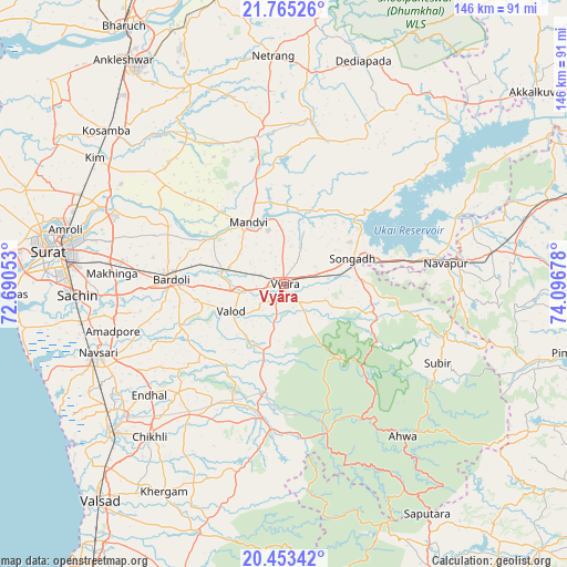
Vyāra GPS coordinates[2]
21° 6' 38.844" North, 73° 23' 37.14" East
| Map corner | latitude | longitude |
|---|---|---|
| Upper-left | 21.76526°, | 72.69053° |
| Center: | 21.11079°, | 73.39365° |
| Lower-right: | 20.45342°, | 74.09678° |
| Map W x H: | 145.9×145.9 km | = 90.7×90.7mi |
| max Lat: | 34.9274° ⇑61.1% North |
| Vyāra: | 21.11079° |
| min Lat: | ⇓38.9% South 8.09008° |
| min Long | Vyāra | max Long |
| 68.82655° | 73.39365° | 96.81° |
| W 7%⇐ | ⇒93% E |
Elevation
Elevation of Vyāra is 90 m = 295 ft, and this is 205.6 m = 675 ft below average elevation for this country.
| Max E: |
3681 m = 12077 ft | 70.5% |
| Avg. | 295.6 m = 970 ft | |
| Vyāra | 90 m = 295 ft | |
Min E: |
1 m = 3 ft | 29.5% |
See also: India elevation on elevation.city.
Geographical zone
Vyāra is located in North Torrid zone (between Equator and Tropic of Cancer). Distance of this Northern Tropic circle is 258.6 km =160.7 mi to North.| Distance of | km | miles | from Vyāra |
|---|---|---|---|
| North Pole | 7659.8 | 4759.6 | to North |
| Arctic Circle | 5053.9 | 3140.3 | to North |
| Tropic Cancer | 258.6 | 160.7 | to North |
| Equator | 2347.3 | 1458.5 | to South |


Nearby cities:
15 places around Vyāra: (largest is in red/bold)
• Abrama
57.8 km =35.9 mi,  240°
240°
• Ahwa
49.7 km =30.9 mi,  142°
142°
• Bārdoli
29.3 km =18.2 mi,  272°
272°
• Chikhli
52.2 km =32.4 mi,  221°
221°
• Gandevi
52.8 km =32.8 mi,  231°
231°
• Jalālpur
54.5 km =33.9 mi,  250°
250°
• Kadod
21.6 km =13.4 mi,  303°
303°
• Kāthor
50.9 km =31.6 mi,  292°
292°
• Māndvi
18.6 km =11.6 mi,  329°
329°
• Navsāri
52.2 km =32.4 mi, 248°
• Sachīn
53.2 km =33.1 mi, 267°
• Songadh
18.8 km =11.7 mi,  69°
69°
• Utrān
56.3 km =35 mi,  284°
284°
• Vānsada
39.3 km =24.4 mi,  184°
184°
• Waghāi
39.4 km =24.5 mi,  163°
163°
Sources, notices
• [Note1] Compared only with cities in India existing in our database
• [Src1] Map data: © OpenStreetMap contributors (CC-BY-SA)
• [Src2] Other city data from geonames.org with taken over terms of usage.
• [Src3] Geographical zone / Annual Mean Temperature by Robert A. Rohde @ Wikipedia
