Waghāi geodata
Waghāi (Gujarat) is a populated place; located in India in Asia/Kolkata (GMT+5.5) time zone. With population of 6,462 people, there are 3255 cities with bigger population in this country. Compared to other cities in India, 62.7% of cities are located further ↑North; 92.5% of cities are located further →East and 60.3% of cities have higher elevation than Waghāi. Note1


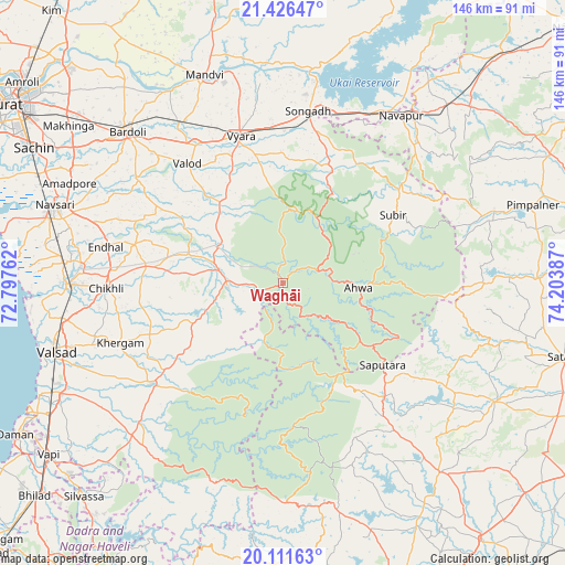
Waghāi GPS coordinates[2]
20° 46' 13.728" North, 73° 30' 2.664" East
| Map corner | latitude | longitude |
|---|---|---|
| Upper-left | 21.42647°, | 72.79762° |
| Center: | 20.77048°, | 73.50074° |
| Lower-right: | 20.11163°, | 74.20387° |
| Map W x H: | 146.2×146.2 km | = 90.8×90.8mi |
| max Lat: | 34.9274° ⇑62.7% North |
| Waghāi: | 20.77048° |
| min Lat: | ⇓37.3% South 8.09008° |
| min Long | Waghāi | max Long |
| 68.82655° | 73.50074° | 96.81° |
| W 7.5%⇐ | ⇒92.5% E |
Elevation
Elevation of Waghāi is 147 m = 482 ft, and this is 148.6 m = 488 ft below average elevation for this country.
| Max E: |
3681 m = 12077 ft | 60.3% |
| Avg. | 295.6 m = 970 ft | |
| Waghāi | 147 m = 482 ft | |
Min E: |
1 m = 3 ft | 39.7% |
See also: India elevation on elevation.city.
Geographical zone
Waghāi is located in North Torrid zone (between Equator and Tropic of Cancer). Distance of this Northern Tropic circle is 296.5 km =184.2 mi to North.| Distance of | km | miles | from Waghāi |
|---|---|---|---|
| North Pole | 7697.6 | 4783.1 | to North |
| Arctic Circle | 5091.7 | 3163.8 | to North |
| Tropic Cancer | 296.5 | 184.2 | to North |
| Equator | 2309.5 | 1435.1 | to South |


Nearby cities:
15 places around Waghāi: (largest is in red/bold)
• Abrama
62.5 km =38.8 mi,  279°
279°
• Ahwa
19.3 km =12 mi,  94°
94°
• Bilimora
56.1 km =34.9 mi,  269°
269°
• Bārdoli
56.3 km =35 mi,  314°
314°
• Chikhli
45.6 km =28.3 mi, 268°
• Dharampur
42.8 km =26.6 mi,  232°
232°
• Gandevi
52.5 km =32.6 mi, 275°
• Kadod
57.6 km =35.8 mi,  329°
329°
• Māndvi
57.6 km =35.8 mi,  339°
339°
• Parnera
62 km =38.5 mi,  247°
247°
• Songadh
44.9 km =27.9 mi,  8°
8°
• Surgāna
27.4 km =17 mi,  148°
148°
• Valsād
61.6 km =38.3 mi, 253°
• Vyāra
39.4 km =24.5 mi, 343°
• Vānsada
14.3 km =8.9 mi,  264°
264°
Sources, notices
• [Note1] Compared only with cities in India existing in our database
• [Src1] Map data: © OpenStreetMap contributors (CC-BY-SA)
• [Src2] Other city data from geonames.org with taken over terms of usage.
• [Src3] Geographical zone / Annual Mean Temperature by Robert A. Rohde @ Wikipedia
