Ahwa geodata
Ahwa (Gujarat) is a populated place; located in India in Asia/Kolkata (GMT+5.5) time zone. With population of 14,321 people, there are 2528 cities with bigger population in this country. Compared to other cities in India, 62.8% of cities are located further ↑North; 91.9% of cities are located further →East and 81.1% of cities have lower elevation than Ahwa. Note1


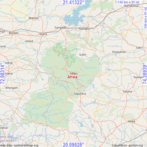
Ahwa GPS coordinates[2]
20° 45' 25.848" North, 73° 41' 10.536" East
| Map corner | latitude | longitude |
|---|---|---|
| Upper-left | 21.41322°, | 72.98314° |
| Center: | 20.75718°, | 73.68626° |
| Lower-right: | 20.09828°, | 74.38939° |
| Map W x H: | 146.2×146.2 km | = 90.8×90.8mi |
| max Lat: | 34.9274° ⇑62.8% North |
| Ahwa: | 20.75718° |
| min Lat: | ⇓37.2% South 8.09008° |
| min Long | Ahwa | max Long |
| 68.82655° | 73.68626° | 96.81° |
| W 8.1%⇐ | ⇒91.9% E |
Elevation
Elevation of Ahwa is 474 m = 1555 ft, and this is 178.4 m = 585 ft above average elevation for this country.
| Max E: |
3681 m = 12077 ft | 18.9% |
| Ahwa | 474 m 1555 ft | |
| Avg. | 295.6 m = 970 ft | |
Min E: |
1 m = 3 ft | 81.1% |
See also: India elevation on elevation.city.
Geographical zone
Ahwa is located in North Torrid zone (between Equator and Tropic of Cancer). Distance of this Northern Tropic circle is 297.9 km =185.1 mi to North.| Distance of | km | miles | from Ahwa |
|---|---|---|---|
| North Pole | 7699.1 | 4784 | to North |
| Arctic Circle | 5093.2 | 3164.8 | to North |
| Tropic Cancer | 297.9 | 185.1 | to North |
| Equator | 2308 | 1434.1 | to South |


Nearby cities:
15 places around Ahwa: (largest is in red/bold)
• Bilimora
75.4 km =46.9 mi,  271°
271°
• Bārdoli
72.2 km =44.9 mi,  304°
304°
• Chikhli
64.8 km =40.3 mi, 270°
• Chāndor
75 km =46.6 mi,  129°
129°
• Dharampur
58.7 km =36.5 mi,  245°
245°
• Gandevi
71.8 km =44.6 mi, 274°
• Kadod
70.4 km =43.7 mi,  316°
316°
• Māndvi
68.1 km =42.3 mi, 324°
• Ozar
77.9 km =48.4 mi,  161°
161°
• Satānā
56.7 km =35.2 mi,  108°
108°
• Songadh
47.6 km =29.6 mi,  344°
344°
• Surgāna
22.6 km =14 mi,  193°
193°
• Vyāra
49.7 km =30.9 mi, 322°
• Vānsada
33.5 km =20.8 mi, 270°
• Waghāi
19.3 km =12 mi, 274°
Sources, notices
• [Note1] Compared only with cities in India existing in our database
• [Src1] Map data: © OpenStreetMap contributors (CC-BY-SA)
• [Src2] Other city data from geonames.org with taken over terms of usage.
• [Src3] Geographical zone / Annual Mean Temperature by Robert A. Rohde @ Wikipedia
