Songadh geodata
Songadh (Gujarat) is a populated place; located in India in Asia/Kolkata (GMT+5.5) time zone. With population of 25,269 people, there are 1683 cities with bigger population in this country. Compared to other cities in India, 60.8% of cities are located further ↑North; 92.2% of cities are located further →East and 65.3% of cities have higher elevation than Songadh. Note1


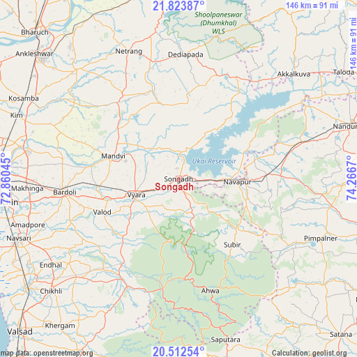
Songadh GPS coordinates[2]
21° 10' 10.776" North, 73° 33' 48.852" East
| Map corner | latitude | longitude |
|---|---|---|
| Upper-left | 21.82387°, | 72.86045° |
| Center: | 21.16966°, | 73.56357° |
| Lower-right: | 20.51254°, | 74.2667° |
| Map W x H: | 145.8×145.8 km | = 90.6×90.6mi |
| max Lat: | 34.9274° ⇑60.8% North |
| Songadh: | 21.16966° |
| min Lat: | ⇓39.2% South 8.09008° |
| min Long | Songadh | max Long |
| 68.82655° | 73.56357° | 96.81° |
| W 7.8%⇐ | ⇒92.2% E |
Elevation
Elevation of Songadh is 118 m = 387 ft, and this is 177.6 m = 583 ft below average elevation for this country.
| Max E: |
3681 m = 12077 ft | 65.3% |
| Avg. | 295.6 m = 970 ft | |
| Songadh | 118 m = 387 ft | |
Min E: |
1 m = 3 ft | 34.7% |
See also: India elevation on elevation.city.
Geographical zone
Songadh is located in North Torrid zone (between Equator and Tropic of Cancer). Distance of this Northern Tropic circle is 252.1 km =156.6 mi to North.| Distance of | km | miles | from Songadh |
|---|---|---|---|
| North Pole | 7653.2 | 4755.5 | to North |
| Arctic Circle | 5047.3 | 3136.2 | to North |
| Tropic Cancer | 252.1 | 156.6 | to North |
| Equator | 2353.8 | 1462.6 | to South |


Nearby cities:
15 places around Songadh: (largest is in red/bold)
• Ahwa
47.6 km =29.6 mi,  164°
164°
• Bārdoli
47.2 km =29.3 mi,  263°
263°
• Chikhli
69.3 km =43.1 mi,  228°
228°
• Gandevi
70.9 km =44.1 mi,  235°
235°
• Kadod
36 km =22.4 mi,  278°
278°
• Kosamba
70.6 km =43.9 mi,  297°
297°
• Kāthor
65.9 km =40.9 mi, 281°
• Māndvi
28.5 km =17.7 mi,  289°
289°
• Navsāri
70.9 km =44.1 mi,  249°
249°
• Sachīn
71.3 km =44.3 mi, 262°
• Surgāna
68.3 km =42.4 mi,  173°
173°
• Utrān
72.6 km =45.1 mi, 275°
• Vyāra
18.8 km =11.7 mi, 249°
• Vānsada
50.2 km =31.2 mi,  204°
204°
• Waghāi
44.9 km =27.9 mi,  188°
188°
Sources, notices
• [Note1] Compared only with cities in India existing in our database
• [Src1] Map data: © OpenStreetMap contributors (CC-BY-SA)
• [Src2] Other city data from geonames.org with taken over terms of usage.
• [Src3] Geographical zone / Annual Mean Temperature by Robert A. Rohde @ Wikipedia
