Belūr geodata
Belūr (Tamil Nadu) is a populated place; located in India in Asia/Kolkata (GMT+5.5) time zone. With population of 9,281 people, there are 3013 cities with bigger population in this country. Compared to other cities in India, 90.6% of cities are located further ↑North; 53.2% of cities are located further ←West and 70.9% of cities have lower elevation than Belūr. Note1


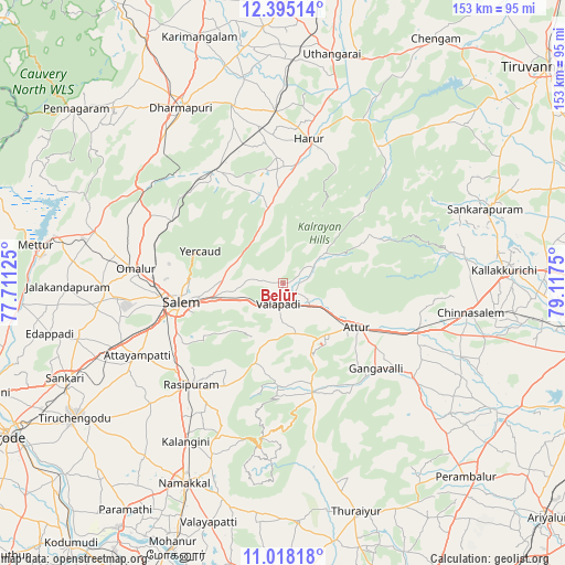
Belūr GPS coordinates[2]
11° 42' 27.072" North, 78° 24' 51.732" East
| Map corner | latitude | longitude |
|---|---|---|
| Upper-left | 12.39514°, | 77.71125° |
| Center: | 11.70752°, | 78.41437° |
| Lower-right: | 11.01818°, | 79.1175° |
| Map W x H: | 153.1×153.1 km | = 95.1×95.1mi |
| max Lat: | 34.9274° ⇑90.6% North |
| Belūr: | 11.70752° |
| min Lat: | ⇓9.4% South 8.09008° |
| min Long | Belūr | max Long |
| 68.82655° | 78.41437° | 96.81° |
| W 53.2%⇐ | ⇒46.8% E |
Elevation
Elevation of Belūr is 336 m = 1102 ft, and this is 40.4 m = 133 ft above average elevation for this country.
| Max E: |
3681 m = 12077 ft | 29.1% |
| Belūr | 336 m 1102 ft | |
| Avg. | 295.6 m = 970 ft | |
Min E: |
1 m = 3 ft | 70.9% |
See also: India elevation on elevation.city.
Geographical zone
Belūr is located in North Torrid zone (between Equator and Tropic of Cancer). Distance of Equator is 1301.8 km =808.9 mi to South.| Distance of | km | miles | from Belūr |
|---|---|---|---|
| North Pole | 8705.3 | 5409.2 | to North |
| Arctic Circle | 6099.4 | 3790 | to North |
| Tropic Cancer | 1304.2 | 810.4 | to North |
| Equator | 1301.8 | 808.9 | to South |


Nearby cities:
15 places around Belūr: (largest is in red/bold)
• Attur
24 km =14.9 mi,  121°
121°
• Gangavalli
34.6 km =21.5 mi,  132°
132°
• Harūr
39 km =24.2 mi,  10°
10°
• Ilampillai
45.8 km =28.5 mi,  255°
255°
• Mallasamudram
48.1 km =29.9 mi,  240°
240°
• Mallāpuram
35.5 km =22.1 mi,  329°
329°
• Māllūr
34.9 km =21.7 mi, 238°
• Nāmagiripettai
32.3 km =20.1 mi,  209°
209°
• Omalur
40.3 km =25 mi,  275°
275°
• Pallippatti
25.9 km =16.1 mi,  356°
356°
• Pāpireddippatti
23.9 km =14.9 mi,  347°
347°
• Rasipuram
37.1 km =23.1 mi,  222°
222°
• Salem
28.8 km =17.9 mi, 258°
• Vīraganūr
43.4 km =27 mi, 126°
• Āttayyāmpatti
43.8 km =27.2 mi, 243°
Sources, notices
• [Note1] Compared only with cities in India existing in our database
• [Src1] Map data: © OpenStreetMap contributors (CC-BY-SA)
• [Src2] Other city data from geonames.org with taken over terms of usage.
• [Src3] Geographical zone / Annual Mean Temperature by Robert A. Rohde @ Wikipedia
