Alagāpuram geodata
Alagāpuram (Tamil Nadu) is a populated place; located in India in Asia/Kolkata (GMT+5.5) time zone. With population of 8,345 people, there are 3092 cities with bigger population in this country. Compared to other cities in India, 90.1% of cities are located further ↑North; 58.3% of cities are located further ←West and 57.7% of cities have higher elevation than Alagāpuram. Note1


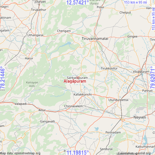
Alagāpuram GPS coordinates[2]
11° 53' 13.38" North, 78° 55' 3.288" East
| Map corner | latitude | longitude |
|---|---|---|
| Upper-left | 12.57421°, | 78.21446° |
| Center: | 11.88705°, | 78.91758° |
| Lower-right: | 11.19815°, | 79.62071° |
| Map W x H: | 153×153 km | = 95.1×95.1mi |
| max Lat: | 34.9274° ⇑90.1% North |
| Alagāpuram: | 11.88705° |
| min Lat: | ⇓9.9% South 8.09008° |
| min Long | Alagāpuram | max Long |
| 68.82655° | 78.91758° | 96.81° |
| W 58.3%⇐ | ⇒41.7% E |
Elevation
Elevation of Alagāpuram is 159 m = 522 ft, and this is 136.6 m = 448 ft below average elevation for this country.
| Max E: |
3681 m = 12077 ft | 57.7% |
| Avg. | 295.6 m = 970 ft | |
| Alagāpuram | 159 m = 522 ft | |
Min E: |
1 m = 3 ft | 42.3% |
See also: India elevation on elevation.city.
Geographical zone
Alagāpuram is located in North Torrid zone (between Equator and Tropic of Cancer). Distance of this Northern Tropic circle is 1284.2 km =798 mi to North.| Distance of | km | miles | from Alagāpuram |
|---|---|---|---|
| North Pole | 8685.3 | 5396.8 | to North |
| Arctic Circle | 6079.5 | 3777.6 | to North |
| Tropic Cancer | 1284.2 | 798 | to North |
| Equator | 1321.7 | 821.3 | to South |


Nearby cities:
15 places around Alagāpuram: (largest is in red/bold)
• Attur
47.4 km =29.5 mi,  226°
226°
• Belūr
58.3 km =36.2 mi,  249°
249°
• Chengam
48.9 km =30.4 mi,  343°
343°
• Chinna Salem
28.5 km =17.7 mi,  189°
189°
• Gangavalli
52.1 km =32.4 mi,  214°
214°
• Harūr
51 km =31.7 mi,  291°
291°
• Kallakkurichchi
16.9 km =10.5 mi,  164°
164°
• Manalūrpettai
23.2 km =14.4 mi,  54°
54°
• Pallippatti
56.4 km =35 mi,  275°
275°
• Pennāthur
52.2 km =32.4 mi,  39°
39°
• Pāpireddippatti
59.8 km =37.2 mi,  273°
273°
• Tirukkoyilur
32.2 km =20 mi,  74°
74°
• Tiruvannāmalai
41.4 km =25.7 mi,  24°
24°
• Vettavalam
43.3 km =26.9 mi,  55°
55°
• Vīraganūr
49.8 km =30.9 mi,  203°
203°
Sources, notices
• [Note1] Compared only with cities in India existing in our database
• [Src1] Map data: © OpenStreetMap contributors (CC-BY-SA)
• [Src2] Other city data from geonames.org with taken over terms of usage.
• [Src3] Geographical zone / Annual Mean Temperature by Robert A. Rohde @ Wikipedia
