Nattam geodata
Nattam (Tamil Nadu) is a populated place; located in India in Asia/Kolkata (GMT+5.5) time zone. With population of 21,888 people, there are 1907 cities with bigger population in this country. Compared to other cities in India, 95.7% of cities are located further ↑North; 51.6% of cities are located further ←West and 60.2% of cities have lower elevation than Nattam. Note1


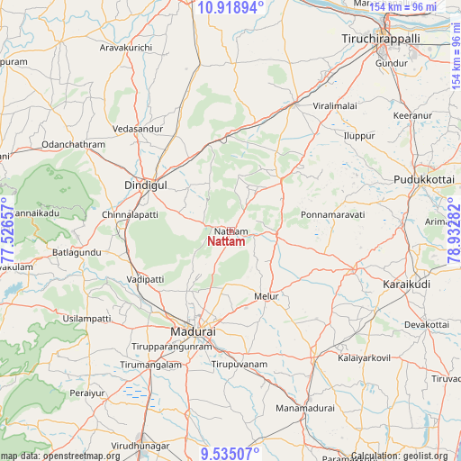
Nattam GPS coordinates[2]
10° 13' 39.936" North, 78° 13' 46.884" East
| Map corner | latitude | longitude |
|---|---|---|
| Upper-left | 10.91894°, | 77.52657° |
| Center: | 10.22776°, | 78.22969° |
| Lower-right: | 9.53507°, | 78.93282° |
| Map W x H: | 153.9×153.9 km | = 95.6×95.6mi |
| max Lat: | 34.9274° ⇑95.7% North |
| Nattam: | 10.22776° |
| min Lat: | ⇓4.3% South 8.09008° |
| min Long | Nattam | max Long |
| 68.82655° | 78.22969° | 96.81° |
| W 51.6%⇐ | ⇒48.4% E |
Elevation
Elevation of Nattam is 252 m = 827 ft, and this is 43.6 m = 143 ft below average elevation for this country.
| Max E: |
3681 m = 12077 ft | 39.8% |
| Avg. | 295.6 m = 970 ft | |
| Nattam | 252 m = 827 ft | |
Min E: |
1 m = 3 ft | 60.2% |
See also: India elevation on elevation.city.
Geographical zone
Nattam is located in North Torrid zone (between Equator and Tropic of Cancer). Distance of Equator is 1137.2 km =706.6 mi to South.| Distance of | km | miles | from Nattam |
|---|---|---|---|
| North Pole | 8869.8 | 5511.4 | to North |
| Arctic Circle | 6264 | 3892.3 | to North |
| Tropic Cancer | 1468.7 | 912.6 | to North |
| Equator | 1137.2 | 706.6 | to South |


Nearby cities:
15 places around Nattam: (largest is in red/bold)
• Alangānallūr
25.2 km =15.7 mi,  217°
217°
• Dindigul
31.5 km =19.6 mi,  299°
299°
• Madurai
36.4 km =22.6 mi,  199°
199°
• Manapparai
47.4 km =29.5 mi,  26°
26°
• Melur
24.8 km =15.4 mi,  151°
151°
• Nilakottai
42.1 km =26.2 mi,  260°
260°
• Ponnamarāvati
34 km =21.1 mi,  80°
80°
• Pālamedu
18.7 km =11.6 mi, 223°
• Sivaganga
50.6 km =31.4 mi, 146°
• Tirupparangunram
42.1 km =26.2 mi, 204°
• Tiruppuvanam
44.8 km =27.8 mi,  176°
176°
• V.S.K.Valasai (Dindigul-Dist.)
13 km =8.1 mi,  318°
318°
• Vadamadurai
27.7 km =17.2 mi,  328°
328°
• Vedasandūr
45.5 km =28.3 mi, 317°
• Vādippatti
33.4 km =20.8 mi,  241°
241°
Sources, notices
• [Note1] Compared only with cities in India existing in our database
• [Src1] Map data: © OpenStreetMap contributors (CC-BY-SA)
• [Src2] Other city data from geonames.org with taken over terms of usage.
• [Src3] Geographical zone / Annual Mean Temperature by Robert A. Rohde @ Wikipedia
