Dharapuram geodata
Dharapuram (Tamil Nadu) is a populated place; located in India in Asia/Kolkata (GMT+5.5) time zone. With population of 72,291 people, there are 606 cities with bigger population in this country. Compared to other cities in India, 94.3% of cities are located further ↑North; 56.9% of cities are located further →East and 59.9% of cities have lower elevation than Dharapuram. Note1


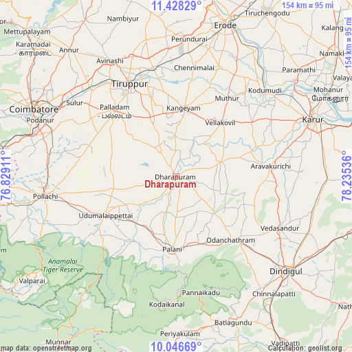
Dharapuram GPS coordinates[2]
10° 44' 17.808" North, 77° 31' 56.028" East
| Map corner | latitude | longitude |
|---|---|---|
| Upper-left | 11.42829°, | 76.82911° |
| Center: | 10.73828°, | 77.53223° |
| Lower-right: | 10.04669°, | 78.23536° |
| Map W x H: | 153.6×153.6 km | = 95.4×95.4mi |
| max Lat: | 34.9274° ⇑94.3% North |
| Dharapuram: | 10.73828° |
| min Lat: | ⇓5.7% South 8.09008° |
| min Long | Dharapuram | max Long |
| 68.82655° | 77.53223° | 96.81° |
| W 43.1%⇐ | ⇒56.9% E |
Elevation
Elevation of Dharapuram is 250 m = 820 ft, and this is 45.6 m = 150 ft below average elevation for this country.
| Max E: |
3681 m = 12077 ft | 40.1% |
| Avg. | 295.6 m = 970 ft | |
| Dharapuram | 250 m = 820 ft | |
Min E: |
1 m = 3 ft | 59.9% |
See also: Dharapuram elevation on elevation.city.
Geographical zone
Dharapuram is located in North Torrid zone (between Equator and Tropic of Cancer). Distance of Equator is 1194 km =741.9 mi to South.| Distance of | km | miles | from Dharapuram |
|---|---|---|---|
| North Pole | 8813.1 | 5476.2 | to North |
| Arctic Circle | 6207.2 | 3857 | to North |
| Tropic Cancer | 1411.9 | 877.3 | to North |
| Equator | 1194 | 741.9 | to South |


Nearby cities:
15 places around Dharapuram: (largest is in red/bold)
• Ayakudi
32.1 km =19.9 mi,  176°
176°
• Chennimalai
48 km =29.8 mi,  9°
9°
• Dhali
45.3 km =28.1 mi,  236°
236°
• Kangayam
29.9 km =18.6 mi, 6°
• Kumaralingam
34.1 km =21.2 mi,  215°
215°
• Kīranūr
16.4 km =10.2 mi,  191°
191°
• Mūlanūr
20.5 km =12.7 mi,  72°
72°
• Palani
32 km =19.9 mi, 182°
• Palladam
38.9 km =24.2 mi,  316°
316°
• Pallappatti
38 km =23.6 mi,  92°
92°
• Periyanegamam
46.9 km =29.1 mi,  270°
270°
• Periyapatti
28.6 km =17.8 mi, 274°
• Tiruppur
46.2 km =28.7 mi,  335°
335°
• Udumalaippettai
35.3 km =21.9 mi, 241°
• Ūttukkuli
48.6 km =30.2 mi,  349°
349°
Sources, notices
• [Note1] Compared only with cities in India existing in our database
• [Src1] Map data: © OpenStreetMap contributors (CC-BY-SA)
• [Src2] Other city data from geonames.org with taken over terms of usage.
• [Src3] Geographical zone / Annual Mean Temperature by Robert A. Rohde @ Wikipedia
