Vettavalam geodata
Vettavalam (Tamil Nadu) is a populated place; located in India in Asia/Kolkata (GMT+5.5) time zone. With population of 13,808 people, there are 2583 cities with bigger population in this country. Compared to other cities in India, 89.5% of cities are located further ↑North; 61.4% of cities are located further ←West and 58% of cities have higher elevation than Vettavalam. Note1


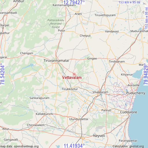
Vettavalam GPS coordinates[2]
12° 6' 27.684" North, 79° 14' 42.576" East
| Map corner | latitude | longitude |
|---|---|---|
| Upper-left | 12.79427°, | 78.54204° |
| Center: | 12.10769°, | 79.24516° |
| Lower-right: | 11.41934°, | 79.94829° |
| Map W x H: | 152.9×152.9 km | = 95×95mi |
| max Lat: | 34.9274° ⇑89.5% North |
| Vettavalam: | 12.10769° |
| min Lat: | ⇓10.5% South 8.09008° |
| min Long | Vettavalam | max Long |
| 68.82655° | 79.24516° | 96.81° |
| W 61.4%⇐ | ⇒38.6% E |
Elevation
Elevation of Vettavalam is 158 m = 518 ft, and this is 137.6 m = 451 ft below average elevation for this country.
| Max E: |
3681 m = 12077 ft | 58% |
| Avg. | 295.6 m = 970 ft | |
| Vettavalam | 158 m = 518 ft | |
Min E: |
1 m = 3 ft | 42% |
See also: India elevation on elevation.city.
Geographical zone
Vettavalam is located in North Torrid zone (between Equator and Tropic of Cancer). Distance of this Northern Tropic circle is 1259.7 km =782.7 mi to North.| Distance of | km | miles | from Vettavalam |
|---|---|---|---|
| North Pole | 8660.8 | 5381.6 | to North |
| Arctic Circle | 6054.9 | 3762.3 | to North |
| Tropic Cancer | 1259.7 | 782.7 | to North |
| Equator | 1346.2 | 836.5 | to South |


Nearby cities:
15 places around Vettavalam: (largest is in red/bold)
• Alagāpuram
43.3 km =26.9 mi,  235°
235°
• Desūr
44.7 km =27.8 mi,  35°
35°
• Gingee
24.7 km =15.3 mi,  49°
49°
• Kallakkurichchi
51.4 km =31.9 mi,  217°
217°
• Manalūrpettai
20 km =12.4 mi, 236°
• Nangilickondan
29.9 km =18.6 mi,  56°
56°
• Panruti
49.7 km =30.9 mi,  137°
137°
• Pennāthur
15.6 km =9.7 mi,  352°
352°
• Polūr
46.9 km =29.1 mi,  343°
343°
• Tindivanam
46.8 km =29.1 mi,  72°
72°
• Tirukkoyilur
16.4 km =10.2 mi,  196°
196°
• Tiruvannāmalai
22.8 km =14.2 mi,  305°
305°
• Valavanur
42.1 km =26.2 mi,  119°
119°
• Vikravāndi
33.6 km =20.9 mi,  103°
103°
• Villupuram
32.7 km =20.3 mi, 124°
Sources, notices
• [Note1] Compared only with cities in India existing in our database
• [Src1] Map data: © OpenStreetMap contributors (CC-BY-SA)
• [Src2] Other city data from geonames.org with taken over terms of usage.
• [Src3] Geographical zone / Annual Mean Temperature by Robert A. Rohde @ Wikipedia
