Payyannūr geodata
Payyannūr (Kerala) is a populated place; located in India in Asia/Kolkata (GMT+5.5) time zone. With population of 70,069 people, there are 621 cities with bigger population in this country. Compared to other cities in India, 89.5% of cities are located further ↑North; 80.9% of cities are located further →East and 95.4% of cities have higher elevation than Payyannūr. Note1


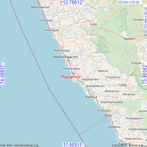
Payyannūr GPS coordinates[2]
12° 5' 36.6" North, 75° 12' 8.964" East
| Map corner | latitude | longitude |
|---|---|---|
| Upper-left | 12.78012°, | 74.49937° |
| Center: | 12.0935°, | 75.20249° |
| Lower-right: | 11.40511°, | 75.90562° |
| Map W x H: | 152.9×152.9 km | = 95×95mi |
| max Lat: | 34.9274° ⇑89.5% North |
| Payyannūr: | 12.0935° |
| min Lat: | ⇓10.5% South 8.09008° |
| min Long | Payyannūr | max Long |
| 68.82655° | 75.20249° | 96.81° |
| W 19.1%⇐ | ⇒80.9% E |
Elevation
Elevation of Payyannūr is 11 m = 36 ft, and this is 284.6 m = 934 ft below average elevation for this country.
| Max E: |
3681 m = 12077 ft | 95.4% |
| Avg. | 295.6 m = 970 ft | |
| Payyannūr | 11 m = 36 ft | |
Min E: |
1 m = 3 ft | 4.6% |
See also: Payyannūr elevation on elevation.city.
Geographical zone
Payyannūr is located in North Torrid zone (between Equator and Tropic of Cancer). Distance of this Northern Tropic circle is 1261.2 km =783.7 mi to North.| Distance of | km | miles | from Payyannūr |
|---|---|---|---|
| North Pole | 8662.4 | 5382.6 | to North |
| Arctic Circle | 6056.5 | 3763.3 | to North |
| Tropic Cancer | 1261.2 | 783.7 | to North |
| Equator | 1344.7 | 835.6 | to South |


Nearby cities:
15 places around Payyannūr: (largest is in red/bold)
• Azhikkal
25.3 km =15.7 mi,  141°
141°
• Dharmadam
45.4 km =28.2 mi, 141°
• Kannavam
57.2 km =35.5 mi,  118°
118°
• Kannur
30.3 km =18.8 mi,  146°
146°
• Kānnangād
26.1 km =16.2 mi,  336°
336°
• Kāsaragod
50.6 km =31.4 mi,  332°
332°
• Mahē
56.6 km =35.2 mi, 140°
• Mattanur
44.1 km =27.4 mi,  114°
114°
• Muluppilagadu
42.6 km =26.5 mi, 140°
• Nīlēshwar
19.9 km =12.4 mi, 338°
• Pāppinisshēri
21.4 km =13.3 mi, 135°
• Sulya
55.7 km =34.6 mi,  21°
21°
• Talipparamba
18 km =11.2 mi, 108°
• Tellicherry
49.7 km =30.9 mi, 140°
• Vīrarājendrapet
66.5 km =41.3 mi,  80°
80°
Sources, notices
• [Note1] Compared only with cities in India existing in our database
• [Src1] Map data: © OpenStreetMap contributors (CC-BY-SA)
• [Src2] Other city data from geonames.org with taken over terms of usage.
• [Src3] Geographical zone / Annual Mean Temperature by Robert A. Rohde @ Wikipedia
