Kānnangād geodata
Kānnangād (Kerala) is a populated place; located in India in Asia/Kolkata (GMT+5.5) time zone. With population of 68,450 people, there are 633 cities with bigger population in this country. Compared to other cities in India, 89% of cities are located further ↑North; 81.9% of cities are located further →East and 89.3% of cities have higher elevation than Kānnangād. Note1


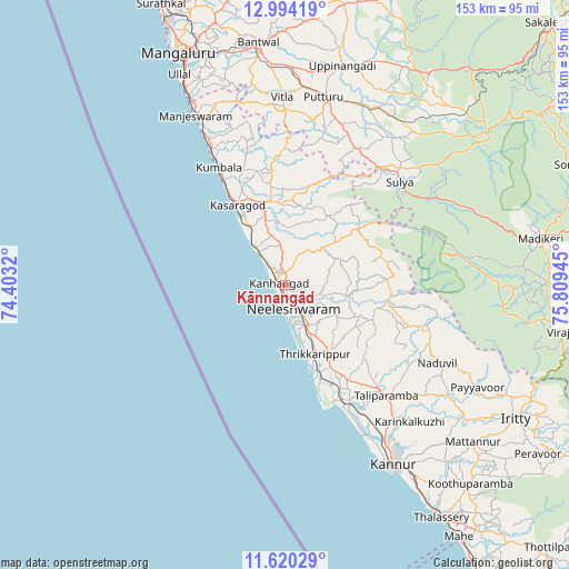
Kānnangād GPS coordinates[2]
12° 18' 29.304" North, 75° 6' 22.752" East
| Map corner | latitude | longitude |
|---|---|---|
| Upper-left | 12.99419°, | 74.4032° |
| Center: | 12.30814°, | 75.10632° |
| Lower-right: | 11.62029°, | 75.80945° |
| Map W x H: | 152.8×152.8 km | = 94.9×94.9mi |
| max Lat: | 34.9274° ⇑89% North |
| Kānnangād: | 12.30814° |
| min Lat: | ⇓11% South 8.09008° |
| min Long | Kānnangād | max Long |
| 68.82655° | 75.10632° | 96.81° |
| W 18.1%⇐ | ⇒81.9% E |
Elevation
Elevation of Kānnangād is 19 m = 62 ft, and this is 276.6 m = 907 ft below average elevation for this country.
| Max E: |
3681 m = 12077 ft | 89.3% |
| Avg. | 295.6 m = 970 ft | |
| Kānnangād | 19 m = 62 ft | |
Min E: |
1 m = 3 ft | 10.7% |
See also: Kānnangād elevation on elevation.city.
Geographical zone
Kānnangād is located in North Torrid zone (between Equator and Tropic of Cancer). Distance of this Northern Tropic circle is 1237.4 km =768.9 mi to North.| Distance of | km | miles | from Kānnangād |
|---|---|---|---|
| North Pole | 8638.5 | 5367.7 | to North |
| Arctic Circle | 6032.6 | 3748.5 | to North |
| Tropic Cancer | 1237.4 | 768.9 | to North |
| Equator | 1368.5 | 850.3 | to South |


Nearby cities:
15 places around Kānnangād: (largest is in red/bold)
• Azhikkal
51 km =31.7 mi,  149°
149°
• Bantvāl
65.2 km =40.5 mi,  353°
353°
• Kannur
56.1 km =34.9 mi, 150°
• Kāsaragod
24.7 km =15.3 mi,  329°
329°
• Madikeri
69.9 km =43.4 mi,  79°
79°
• Manjēshvar
50.8 km =31.6 mi, 332°
• Mattanur
65.8 km =40.9 mi,  129°
129°
• Muluppilagadu
68 km =42.3 mi, 146°
• Nīlēshwar
6.2 km =3.9 mi, 149°
• Payyannūr
26.1 km =16.2 mi,  156°
156°
• Puttūr
51.3 km =31.9 mi,  11°
11°
• Pāppinisshēri
46.6 km =29 mi, 146°
• Sulya
41.5 km =25.8 mi,  47°
47°
• Talipparamba
40.4 km =25.1 mi,  137°
137°
• Ullal
61.4 km =38.2 mi, 334°
Sources, notices
• [Note1] Compared only with cities in India existing in our database
• [Src1] Map data: © OpenStreetMap contributors (CC-BY-SA)
• [Src2] Other city data from geonames.org with taken over terms of usage.
• [Src3] Geographical zone / Annual Mean Temperature by Robert A. Rohde @ Wikipedia
