Rājpīpla geodata
Rājpīpla (Gujarat) is a populated place; located in India in Asia/Kolkata (GMT+5.5) time zone. With population of 35,392 people, there are 1228 cities with bigger population in this country. Compared to other cities in India, 57.2% of cities are located further ↑North; 92.6% of cities are located further →East and 80.7% of cities have higher elevation than Rājpīpla. Note1


Rājpīpla GPS coordinates[2]
21° 52' 0.012" North, 73° 30' 0" East
| Map corner | latitude | longitude |
|---|---|---|
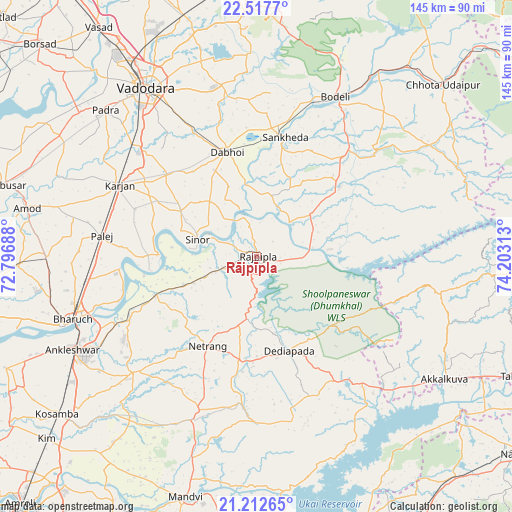
| Upper-left | 22.5177°, | 72.79688° |
| Center: | 21.86667°, | 73.5° |
| Lower-right: | 21.21265°, | 74.20313° |
| Map W x H: | 145.1×145.1 km | = 90.2×90.2mi |
| max Lat: | 34.9274° ⇑57.2% North |
| Rājpīpla: | 21.86667° |
| min Lat: | ⇓42.8% South 8.09008° |
| min Long | Rājpīpla | max Long |
| 68.82655° | 73.5° | 96.81° |
| W 7.4%⇐ | ⇒92.6% E |
Elevation
Elevation of Rājpīpla is 45 m = 148 ft, and this is 250.6 m = 822 ft below average elevation for this country.
| Max E: |
3681 m = 12077 ft | 80.7% |
| Avg. | 295.6 m = 970 ft | |
| Rājpīpla | 45 m = 148 ft | |
Min E: |
1 m = 3 ft | 19.3% |
See also: India elevation on elevation.city.
Geographical zone
Rājpīpla is located in North Torrid zone (between Equator and Tropic of Cancer). Distance of this Northern Tropic circle is 174.6 km =108.5 mi to North.| Distance of | km | miles | from Rājpīpla |
|---|---|---|---|
| North Pole | 7575.7 | 4707.3 | to North |
| Arctic Circle | 4969.8 | 3088.1 | to North |
| Tropic Cancer | 174.6 | 108.5 | to North |
| Equator | 2431.3 | 1510.7 | to South |


Nearby cities:
15 places around Rājpīpla: (largest is in red/bold)
• Amod
66.4 km =41.3 mi,  282°
282°
• Ankleshwar
58.8 km =36.5 mi,  243°
243°
• Bharūch
56.9 km =35.4 mi,  250°
250°
• Dabhoi
35.9 km =22.3 mi,  348°
348°
• Hālol
70.8 km =44 mi,  357°
357°
• Jetpur
63.7 km =39.6 mi,  33°
33°
• Kawānt
62.1 km =38.6 mi,  66°
66°
• Kosamba
71.8 km =44.6 mi,  231°
231°
• Māndvi
70.9 km =44.1 mi,  196°
196°
• Padra
59.6 km =37 mi,  314°
314°
• Sankheda
34.7 km =21.6 mi,  13°
13°
• Shivrājpur
62.9 km =39.1 mi, 10°
• Sinor
17.3 km =10.7 mi,  286°
286°
• Vadodara
56.7 km =35.2 mi,  327°
327°
• Vāghodia
49.8 km =30.9 mi, 348°
Sources, notices
• [Note1] Compared only with cities in India existing in our database
• [Src1] Map data: © OpenStreetMap contributors (CC-BY-SA)
• [Src2] Other city data from geonames.org with taken over terms of usage.
• [Src3] Geographical zone / Annual Mean Temperature by Robert A. Rohde @ Wikipedia
