Melur geodata
Melur (Tamil Nadu) is a populated place; located in India in Asia/Kolkata (GMT+5.5) time zone. With population of 33,839 people, there are 1283 cities with bigger population in this country. Compared to other cities in India, 96.4% of cities are located further ↑North; 52.6% of cities are located further ←West and 58.7% of cities have higher elevation than Melur. Note1


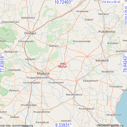
Melur GPS coordinates[2]
10° 1' 56.676" North, 78° 20' 21.48" East
| Map corner | latitude | longitude |
|---|---|---|
| Upper-left | 10.72403°, | 77.63618° |
| Center: | 10.03241°, | 78.3393° |
| Lower-right: | 9.33931°, | 79.04243° |
| Map W x H: | 154×154 km | = 95.7×95.7mi |
| max Lat: | 34.9274° ⇑96.4% North |
| Melur: | 10.03241° |
| min Lat: | ⇓3.6% South 8.09008° |
| min Long | Melur | max Long |
| 68.82655° | 78.3393° | 96.81° |
| W 52.6%⇐ | ⇒47.4% E |
Elevation
Elevation of Melur is 154 m = 505 ft, and this is 141.6 m = 465 ft below average elevation for this country.
| Max E: |
3681 m = 12077 ft | 58.7% |
| Avg. | 295.6 m = 970 ft | |
| Melur | 154 m = 505 ft | |
Min E: |
1 m = 3 ft | 41.3% |
See also: India elevation on elevation.city.
Geographical zone
Melur is located in North Torrid zone (between Equator and Tropic of Cancer). Distance of Equator is 1115.5 km =693.1 mi to South.| Distance of | km | miles | from Melur |
|---|---|---|---|
| North Pole | 8891.6 | 5525 | to North |
| Arctic Circle | 6285.7 | 3905.8 | to North |
| Tropic Cancer | 1490.4 | 926.1 | to North |
| Equator | 1115.5 | 693.1 | to South |


Nearby cities:
15 places around Melur: (largest is in red/bold)
• Alangānallūr
27.3 km =17 mi,  273°
273°
• Kariapatti
47.6 km =29.6 mi,  213°
213°
• Kāraikkudi
47.1 km =29.3 mi,  85°
85°
• Madurai
27.2 km =16.9 mi,  242°
242°
• Manamadurai
42.5 km =26.4 mi,  160°
160°
• Mangalam
44.4 km =27.6 mi,  132°
132°
• Nattam
24.8 km =15.4 mi,  331°
331°
• Nāttarasankottai
29.6 km =18.4 mi, 127°
• Ponnamarāvati
35 km =21.7 mi,  37°
37°
• Pālamedu
26 km =16.2 mi,  288°
288°
• Sivaganga
26 km =16.2 mi,  142°
142°
• Tirupparangunram
33.6 km =20.9 mi, 240°
• Tiruppuvanam
24.7 km =15.3 mi,  201°
201°
• V.S.K.Valasai (Dindigul-Dist.)
37.6 km =23.4 mi, 326°
• Vādippatti
41.8 km =26 mi,  278°
278°
Sources, notices
• [Note1] Compared only with cities in India existing in our database
• [Src1] Map data: © OpenStreetMap contributors (CC-BY-SA)
• [Src2] Other city data from geonames.org with taken over terms of usage.
• [Src3] Geographical zone / Annual Mean Temperature by Robert A. Rohde @ Wikipedia
