Kallupatti geodata
Kallupatti (Tamil Nadu) is a populated place; located in India in Asia/Kolkata (GMT+5.5) time zone. With population of 9,725 people, there are 2974 cities with bigger population in this country. Compared to other cities in India, 97.3% of cities are located further ↑North; 52.8% of cities are located further →East and 61.9% of cities have higher elevation than Kallupatti. Note1


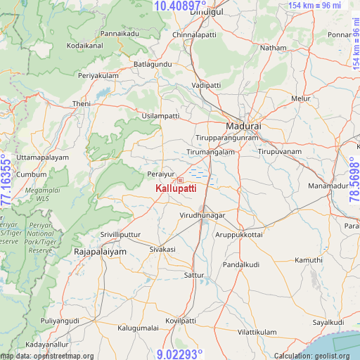
Kallupatti GPS coordinates[2]
9° 43' 0.012" North, 77° 52' 0.012" East
| Map corner | latitude | longitude |
|---|---|---|
| Upper-left | 10.40897°, | 77.16355° |
| Center: | 9.71667°, | 77.86667° |
| Lower-right: | 9.02293°, | 78.5698° |
| Map W x H: | 154.1×154.1 km | = 95.8×95.8mi |
| max Lat: | 34.9274° ⇑97.3% North |
| Kallupatti: | 9.71667° |
| min Lat: | ⇓2.7% South 8.09008° |
| min Long | Kallupatti | max Long |
| 68.82655° | 77.86667° | 96.81° |
| W 47.2%⇐ | ⇒52.8% E |
Elevation
Elevation of Kallupatti is 138 m = 453 ft, and this is 157.6 m = 517 ft below average elevation for this country.
| Max E: |
3681 m = 12077 ft | 61.9% |
| Avg. | 295.6 m = 970 ft | |
| Kallupatti | 138 m = 453 ft | |
Min E: |
1 m = 3 ft | 38.1% |
See also: India elevation on elevation.city.
Geographical zone
Kallupatti is located in North Torrid zone (between Equator and Tropic of Cancer). Distance of Equator is 1080.4 km =671.3 mi to South.| Distance of | km | miles | from Kallupatti |
|---|---|---|---|
| North Pole | 8926.7 | 5546.8 | to North |
| Arctic Circle | 6320.8 | 3927.6 | to North |
| Tropic Cancer | 1525.5 | 947.9 | to North |
| Equator | 1080.4 | 671.3 | to South |


Nearby cities:
15 places around Kallupatti: (largest is in red/bold)
• Alangānallūr
44.1 km =27.4 mi,  33°
33°
• Aruppukkottai
34.1 km =21.2 mi,  132°
132°
• Elumalai
24.7 km =15.3 mi,  311°
311°
• Kariapatti
26 km =16.2 mi,  100°
100°
• Madurai
35.7 km =22.2 mi,  50°
50°
• Peraiyur
8.7 km =5.4 mi,  284°
284°
• Sattur
40.6 km =25.2 mi,  171°
171°
• Sivakasi
30.6 km =19 mi,  194°
194°
• Srivilliputhur
34.2 km =21.3 mi,  228°
228°
• Tirupparangunram
29.1 km =18.1 mi, 50°
• Tiruttangal
26.2 km =16.3 mi, 188°
• Usilampatti
29.4 km =18.3 mi,  342°
342°
• Virudunagar
17.7 km =11 mi,  145°
145°
• Vādippatti
42.2 km =26.2 mi,  14°
14°
• Āndippatti
41.3 km =25.7 mi,  319°
319°
Sources, notices
• [Note1] Compared only with cities in India existing in our database
• [Src1] Map data: © OpenStreetMap contributors (CC-BY-SA)
• [Src2] Other city data from geonames.org with taken over terms of usage.
• [Src3] Geographical zone / Annual Mean Temperature by Robert A. Rohde @ Wikipedia
