Dātāganj geodata
Dātāganj (Uttar Pradesh) is a populated place; located in India in Asia/Kolkata (GMT+5.5) time zone. With population of 24,562 people, there are 1733 cities with bigger population in this country. Compared to other cities in India, 84.6% of cities are located further ↓South; 62.7% of cities are located further ←West and 57.7% of cities have higher elevation than Dātāganj. Note1


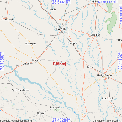
Dātāganj GPS coordinates[2]
28° 1' 31.08" North, 79° 24' 29.484" East
| Map corner | latitude | longitude |
|---|---|---|
| Upper-left | 28.64418°, | 78.70507° |
| Center: | 28.0253°, | 79.40819° |
| Lower-right: | 27.40284°, | 80.11132° |
| Map W x H: | 138×138 km | = 85.7×85.7mi |
| max Lat: | 34.9274° ⇑15.4% North |
| Dātāganj: | 28.0253° |
| min Lat: | ⇓84.6% South 8.09008° |
| min Long | Dātāganj | max Long |
| 68.82655° | 79.40819° | 96.81° |
| W 62.7%⇐ | ⇒37.3% E |
Elevation
Elevation of Dātāganj is 159 m = 522 ft, and this is 136.6 m = 448 ft below average elevation for this country.
| Max E: |
3681 m = 12077 ft | 57.7% |
| Avg. | 295.6 m = 970 ft | |
| Dātāganj | 159 m = 522 ft | |
Min E: |
1 m = 3 ft | 42.3% |
See also: India elevation on elevation.city.
Geographical zone
Dātāganj is located in North temperate zone (between Tropic of Cancer and the Arctic Circle). Distance of this Northern Tropic circle is 510.2 km =317 mi to South.| Distance of | km | miles | from Dātāganj |
|---|---|---|---|
| North Pole | 6890.9 | 4281.8 | to North |
| Arctic Circle | 4285.1 | 2662.6 | to North |
| Tropic Cancer | 510.2 | 317 | to South |
| Equator | 3116.1 | 1936.3 | to South |


Nearby cities:
15 places around Dātāganj: (largest is in red/bold)
• Aonla
36.5 km =22.7 mi,  319°
319°
• Bareilly
38 km =23.6 mi,  3°
3°
• Budaun
27.7 km =17.2 mi,  272°
272°
• Bīsalpur
48.9 km =30.4 mi,  52°
52°
• Farīdpur
24.3 km =15.1 mi,  32°
32°
• Jalālābād
41.2 km =25.6 mi,  143°
143°
• Kakrāla
25.6 km =15.9 mi,  234°
234°
• Kampil
47.7 km =29.6 mi,  195°
195°
• Khudāganj
32.9 km =20.4 mi,  65°
65°
• Kānt
44.6 km =27.7 mi,  122°
122°
• Mīrānpur Katra
25.5 km =15.8 mi,  88°
88°
• Tilhar
33.1 km =20.6 mi,  102°
102°
• Ujhāni
39.3 km =24.4 mi, 266°
• Usehat
30.3 km =18.8 mi,  213°
213°
• Wazīrganj
40.2 km =25 mi,  300°
300°
Sources, notices
• [Note1] Compared only with cities in India existing in our database
• [Src1] Map data: © OpenStreetMap contributors (CC-BY-SA)
• [Src2] Other city data from geonames.org with taken over terms of usage.
• [Src3] Geographical zone / Annual Mean Temperature by Robert A. Rohde @ Wikipedia
