Ganj Dundwāra geodata
Ganj Dundwāra (Uttar Pradesh) is a populated place; located in India in Asia/Kolkata (GMT+5.5) time zone. With population of 46,314 people, there are 955 cities with bigger population in this country. Compared to other cities in India, 83.3% of cities are located further ↓South; 58.5% of cities are located further ←West and 55.3% of cities have higher elevation than Ganj Dundwāra. Note1


Ganj Dundwāra GPS coordinates[2]
27° 43' 59.088" North, 78° 56' 28.284" East
| Map corner | latitude | longitude |
|---|---|---|
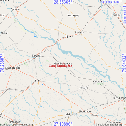
| Upper-left | 28.35365°, | 78.23807° |
| Center: | 27.73308°, | 78.94119° |
| Lower-right: | 27.10896°, | 79.64432° |
| Map W x H: | 138.4×138.4 km | = 86×86mi |
| max Lat: | 34.9274° ⇑16.7% North |
| Ganj Dundwāra: | 27.73308° |
| min Lat: | ⇓83.3% South 8.09008° |
| min Long | Ganj Dundwāra | max Long |
| 68.82655° | 78.94119° | 96.81° |
| W 58.5%⇐ | ⇒41.5% E |
Elevation
Elevation of Ganj Dundwāra is 173 m = 568 ft, and this is 122.6 m = 402 ft below average elevation for this country.
| Max E: |
3681 m = 12077 ft | 55.3% |
| Avg. | 295.6 m = 970 ft | |
| Ganj Dundwāra | 173 m = 568 ft | |
Min E: |
1 m = 3 ft | 44.7% |
See also: Ganj Dundwāra elevation on elevation.city.
Geographical zone
Ganj Dundwāra is located in North temperate zone (between Tropic of Cancer and the Arctic Circle). Distance of this Northern Tropic circle is 477.7 km =296.8 mi to South.| Distance of | km | miles | from Ganj Dundwāra |
|---|---|---|---|
| North Pole | 6923.4 | 4302 | to North |
| Arctic Circle | 4317.5 | 2682.8 | to North |
| Tropic Cancer | 477.7 | 296.8 | to South |
| Equator | 3083.6 | 1916.1 | to South |


Nearby cities:
15 places around Ganj Dundwāra: (largest is in red/bold)
• Alīganj
35 km =21.7 mi,  139°
139°
• Amānpur
20.1 km =12.5 mi,  263°
263°
• Budaun
38.5 km =23.9 mi,  28°
28°
• Kakrāla
30.6 km =19 mi,  54°
54°
• Kampil
35.7 km =22.2 mi,  112°
112°
• Kāsganj
30.3 km =18.8 mi,  286°
286°
• Mārahra
36.6 km =22.7 mi,  270°
270°
• Patiāli
7.3 km =4.5 mi,  129°
129°
• Sahaswān
42.1 km =26.2 mi,  333°
333°
• Sahāwar
12.7 km =7.9 mi,  303°
303°
• Sakīt
36.8 km =22.9 mi,  205°
205°
• Sidhpura
13.2 km =8.2 mi, 212°
• Soron
26 km =16.2 mi,  312°
312°
• Ujhāni
30.7 km =19.1 mi,  12°
12°
• Usehat
30 km =18.6 mi,  76°
76°
Sources, notices
• [Note1] Compared only with cities in India existing in our database
• [Src1] Map data: © OpenStreetMap contributors (CC-BY-SA)
• [Src2] Other city data from geonames.org with taken over terms of usage.
• [Src3] Geographical zone / Annual Mean Temperature by Robert A. Rohde @ Wikipedia
