Kāsganj geodata
Kāsganj (Uttar Pradesh) is a populated place; located in India in Asia/Kolkata (GMT+5.5) time zone. With population of 99,462 people, there are 443 cities with bigger population in this country. Compared to other cities in India, 83.6% of cities are located further ↓South; 55.6% of cities are located further ←West and 53.8% of cities have higher elevation than Kāsganj. Note1


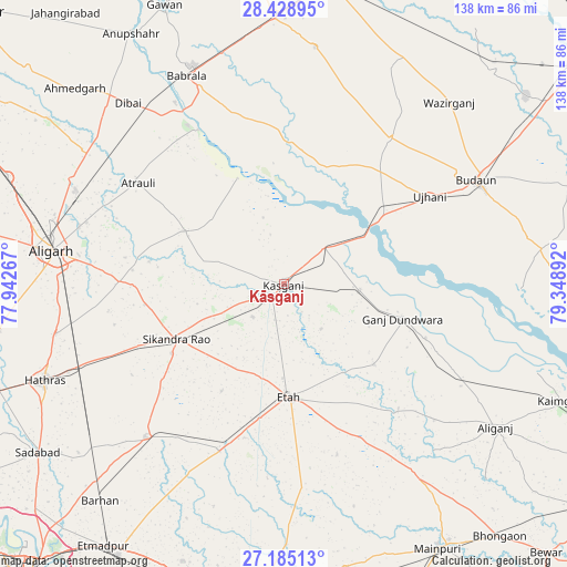
Kāsganj GPS coordinates[2]
27° 48' 31.752" North, 78° 38' 44.844" East
| Map corner | latitude | longitude |
|---|---|---|
| Upper-left | 28.42895°, | 77.94267° |
| Center: | 27.80882°, | 78.64579° |
| Lower-right: | 27.18513°, | 79.34892° |
| Map W x H: | 138.3×138.3 km | = 85.9×85.9mi |
| max Lat: | 34.9274° ⇑16.4% North |
| Kāsganj: | 27.80882° |
| min Lat: | ⇓83.6% South 8.09008° |
| min Long | Kāsganj | max Long |
| 68.82655° | 78.64579° | 96.81° |
| W 55.6%⇐ | ⇒44.4% E |
Elevation
Elevation of Kāsganj is 181 m = 594 ft, and this is 114.6 m = 376 ft below average elevation for this country.
| Max E: |
3681 m = 12077 ft | 53.8% |
| Avg. | 295.6 m = 970 ft | |
| Kāsganj | 181 m = 594 ft | |
Min E: |
1 m = 3 ft | 46.2% |
See also: Kāsganj elevation on elevation.city.
Geographical zone
Kāsganj is located in North temperate zone (between Tropic of Cancer and the Arctic Circle). Distance of this Northern Tropic circle is 486.1 km =302 mi to South.| Distance of | km | miles | from Kāsganj |
|---|---|---|---|
| North Pole | 6915 | 4296.8 | to North |
| Arctic Circle | 4309.1 | 2677.5 | to North |
| Tropic Cancer | 486.1 | 302 | to South |
| Equator | 3092.1 | 1921.3 | to South |


Nearby cities:
15 places around Kāsganj: (largest is in red/bold)
• Amānpur
14.1 km =8.8 mi,  139°
139°
• Atraulī
43.1 km =26.8 mi,  304°
304°
• Bilsi
44.1 km =27.4 mi,  36°
36°
• Chharra
27.3 km =17 mi, 298°
• Ganj Dundwāra
30.3 km =18.8 mi,  106°
106°
• Jalālī
39.2 km =24.4 mi,  279°
279°
• Mārahra
11 km =6.8 mi,  223°
223°
• Patiāli
37.1 km =23.1 mi, 110°
• Sahaswān
31.1 km =19.3 mi,  19°
19°
• Sahāwar
18.5 km =11.5 mi,  94°
94°
• Sakīt
43.6 km =27.1 mi,  162°
162°
• Sidhpura
29.4 km =18.3 mi,  131°
131°
• Sikandra Rao
29.4 km =18.3 mi,  242°
242°
• Soron
13.4 km =8.3 mi,  47°
47°
• Ujhāni
41.7 km =25.9 mi,  58°
58°
Sources, notices
• [Note1] Compared only with cities in India existing in our database
• [Src1] Map data: © OpenStreetMap contributors (CC-BY-SA)
• [Src2] Other city data from geonames.org with taken over terms of usage.
• [Src3] Geographical zone / Annual Mean Temperature by Robert A. Rohde @ Wikipedia
