Pahlgām geodata
Pahlgām (Jammu and Kashmir) is a populated place; located in India in Asia/Kolkata (GMT+5.5) time zone. With population of 7,750 people, there are 3145 cities with bigger population in this country. Compared to other cities in India, 99.5% of cities are located further ↓South; 80.1% of cities are located further →East and 99.5% of cities have lower elevation than Pahlgām. Note1


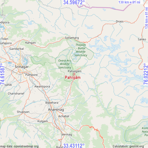
Pahlgām GPS coordinates[2]
34° 0' 57.312" North, 75° 19' 8.364" East
| Map corner | latitude | longitude |
|---|---|---|
| Upper-left | 34.59672°, | 74.61587° |
| Center: | 34.01592°, | 75.31899° |
| Lower-right: | 33.43112°, | 76.02212° |
| Map W x H: | 129.6×129.6 km | = 80.5×80.5mi |
| max Lat: | 34.9274° ⇑0.5% North |
| Pahlgām: | 34.01592° |
| min Lat: | ⇓99.5% South 8.09008° |
| min Long | Pahlgām | max Long |
| 68.82655° | 75.31899° | 96.81° |
| W 19.9%⇐ | ⇒80.1% E |
Elevation
Elevation of Pahlgām is 2155 m = 7070 ft, and this is 1859.4 m = 6100 ft above average elevation for this country.
| Max E: |
3681 m = 12077 ft | 0.5% |
| Pahlgām | 2155 m 7070 ft | |
| Avg. | 295.6 m = 970 ft | |
Min E: |
1 m = 3 ft | 99.5% |
See also: India elevation on elevation.city.
Geographical zone
Pahlgām is located in North temperate zone (between Tropic of Cancer and the Arctic Circle). Distance of this Northern Tropic circle is 1176.3 km =730.9 mi to South.| Distance of | km | miles | from Pahlgām |
|---|---|---|---|
| North Pole | 6224.8 | 3867.9 | to North |
| Arctic Circle | 3619 | 2248.7 | to North |
| Tropic Cancer | 1176.3 | 730.9 | to South |
| Equator | 3782.2 | 2350.1 | to South |


Nearby cities:
15 places around Pahlgām: (largest is in red/bold)
• Anantnag
35.2 km =21.9 mi,  205°
205°
• Awantipur
30 km =18.6 mi,  249°
249°
• Banihāl
65.4 km =40.6 mi,  189°
189°
• Bijbehara
31.5 km =19.6 mi,  218°
218°
• Gāndarbal
55.3 km =34.4 mi,  295°
295°
• Kulgam
49.7 km =30.9 mi, 213°
• Māgām
67.7 km =42.1 mi,  277°
277°
• Pulwama
41.8 km =26 mi, 247°
• Qāzigund
45 km =28 mi,  201°
201°
• Shupīyan
55.7 km =34.6 mi,  233°
233°
• Soyībug
56.9 km =35.4 mi, 276°
• Srinagar
47.9 km =29.8 mi, 279°
• Sumbal
66.3 km =41.2 mi,  291°
291°
• Trāl
21.2 km =13.2 mi,  242°
242°
• Tsrār Sharīf
53.8 km =33.4 mi, 251°
Sources, notices
• [Note1] Compared only with cities in India existing in our database
• [Src1] Map data: © OpenStreetMap contributors (CC-BY-SA)
• [Src2] Other city data from geonames.org with taken over terms of usage.
• [Src3] Geographical zone / Annual Mean Temperature by Robert A. Rohde @ Wikipedia
