Mandapam geodata
Mandapam (Tamil Nadu) is a populated place; located in India in Asia/Kolkata (GMT+5.5) time zone. With population of 15,073 people, there are 2454 cities with bigger population in this country. Compared to other cities in India, 98.2% of cities are located further ↑North; 60.1% of cities are located further ←West and 99.4% of cities have higher elevation than Mandapam. Note1


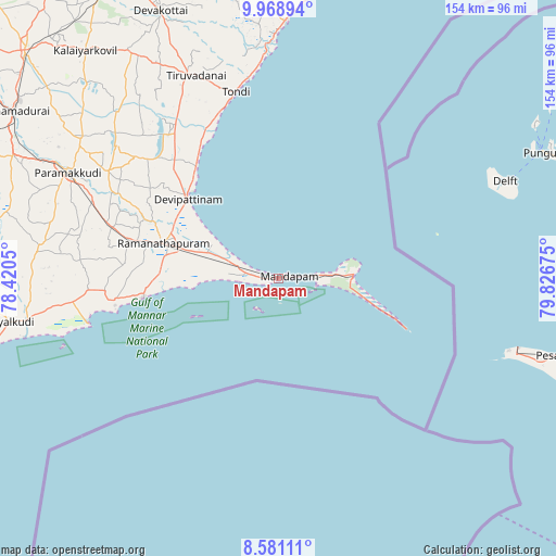
Mandapam GPS coordinates[2]
9° 16' 32.556" North, 79° 7' 25.032" East
| Map corner | latitude | longitude |
|---|---|---|
| Upper-left | 9.96894°, | 78.4205° |
| Center: | 9.27571°, | 79.12362° |
| Lower-right: | 8.58111°, | 79.82675° |
| Map W x H: | 154.3×154.3 km | = 95.9×95.9mi |
| max Lat: | 34.9274° ⇑98.2% North |
| Mandapam: | 9.27571° |
| min Lat: | ⇓1.8% South 8.09008° |
| min Long | Mandapam | max Long |
| 68.82655° | 79.12362° | 96.81° |
| W 60.1%⇐ | ⇒39.9% E |
Elevation
Elevation of Mandapam is 6 m = 20 ft, and this is 289.6 m = 950 ft below average elevation for this country.
| Max E: |
3681 m = 12077 ft | 99.4% |
| Avg. | 295.6 m = 970 ft | |
| Mandapam | 6 m = 20 ft | |
Min E: |
1 m = 3 ft | 0.6% |
See also: India elevation on elevation.city.
Geographical zone
Mandapam is located in North Torrid zone (between Equator and Tropic of Cancer). Distance of Equator is 1031.4 km =640.9 mi to South.| Distance of | km | miles | from Mandapam |
|---|---|---|---|
| North Pole | 8975.7 | 5577.2 | to North |
| Arctic Circle | 6369.8 | 3958 | to North |
| Tropic Cancer | 1574.6 | 978.4 | to North |
| Equator | 1031.4 | 640.9 | to South |


Nearby cities:
15 places around Mandapam: (largest is in red/bold)
• Abirāmam
77.3 km =48 mi,  283°
283°
• Devakottai
81.6 km =50.7 mi,  336°
336°
• Kamuthi
83.6 km =51.9 mi, 280°
• Keelakarai
37.4 km =23.2 mi,  262°
262°
• Manamadurai
84.1 km =52.3 mi,  301°
301°
• Mangalam
75.9 km =47.2 mi,  315°
315°
• Mudukulattūr
67.3 km =41.8 mi, 276°
• Nambutalai
51.9 km =32.2 mi,  345°
345°
• Paramagudi
65.7 km =40.8 mi, 297°
• Periyapattinam
24.3 km =15.1 mi,  269°
269°
• Ramanathapuram
33.9 km =21.1 mi,  288°
288°
• Rameswaram
20.8 km =12.9 mi,  86°
86°
• Sāyalkudi
75.2 km =46.7 mi, 260°
• Tiruppālaikudi
37.6 km =23.4 mi, 323°
• Tondi
53.1 km =33 mi, 347°
Sources, notices
• [Note1] Compared only with cities in India existing in our database
• [Src1] Map data: © OpenStreetMap contributors (CC-BY-SA)
• [Src2] Other city data from geonames.org with taken over terms of usage.
• [Src3] Geographical zone / Annual Mean Temperature by Robert A. Rohde @ Wikipedia
