Paramagudi geodata
Paramagudi (Tamil Nadu) is a populated place; located in India in Asia/Kolkata (GMT+5.5) time zone. With population of 85,695 people, there are 521 cities with bigger population in this country. Compared to other cities in India, 97.6% of cities are located further ↑North; 55.1% of cities are located further ←West and 80.5% of cities have higher elevation than Paramagudi. Note1


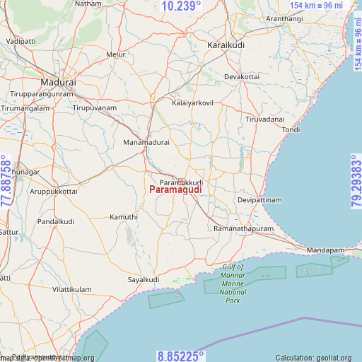
Paramagudi GPS coordinates[2]
9° 32' 46.788" North, 78° 35' 26.52" East
| Map corner | latitude | longitude |
|---|---|---|
| Upper-left | 10.239°, | 77.88758° |
| Center: | 9.54633°, | 78.5907° |
| Lower-right: | 8.85225°, | 79.29383° |
| Map W x H: | 154.2×154.2 km | = 95.8×95.8mi |
| max Lat: | 34.9274° ⇑97.6% North |
| Paramagudi: | 9.54633° |
| min Lat: | ⇓2.4% South 8.09008° |
| min Long | Paramagudi | max Long |
| 68.82655° | 78.5907° | 96.81° |
| W 55.1%⇐ | ⇒44.9% E |
Elevation
Elevation of Paramagudi is 46 m = 151 ft, and this is 249.6 m = 819 ft below average elevation for this country.
| Max E: |
3681 m = 12077 ft | 80.5% |
| Avg. | 295.6 m = 970 ft | |
| Paramagudi | 46 m = 151 ft | |
Min E: |
1 m = 3 ft | 19.5% |
See also: Paramagudi elevation on elevation.city.
Geographical zone
Paramagudi is located in North Torrid zone (between Equator and Tropic of Cancer). Distance of Equator is 1061.5 km =659.6 mi to South.| Distance of | km | miles | from Paramagudi |
|---|---|---|---|
| North Pole | 8945.6 | 5558.5 | to North |
| Arctic Circle | 6339.7 | 3939.3 | to North |
| Tropic Cancer | 1544.5 | 959.7 | to North |
| Equator | 1061.5 | 659.6 | to South |


Nearby cities:
15 places around Paramagudi: (largest is in red/bold)
• Abirāmam
20.2 km =12.6 mi,  235°
235°
• Devakottai
51.3 km =31.9 mi,  29°
29°
• Kamuthi
28.4 km =17.6 mi, 237°
• Keelakarai
41 km =25.5 mi,  148°
148°
• Manamadurai
19.3 km =12 mi,  317°
317°
• Mangalam
24.9 km =15.5 mi,  12°
12°
• Mudukulattūr
24.3 km =15.1 mi,  200°
200°
• Nambutalai
49.9 km =31 mi,  66°
66°
• Nāttarasankottai
36.1 km =22.4 mi,  353°
353°
• Periyapattinam
45.8 km =28.5 mi,  131°
131°
• Ramanathapuram
32.7 km =20.3 mi, 126°
• Sivaganga
35.4 km =22 mi,  340°
340°
• Sāyalkudi
44.8 km =27.8 mi, 200°
• Tiruppuvanam
47.9 km =29.8 mi,  310°
310°
• Tiruppālaikudi
35.8 km =22.2 mi,  90°
90°
Sources, notices
• [Note1] Compared only with cities in India existing in our database
• [Src1] Map data: © OpenStreetMap contributors (CC-BY-SA)
• [Src2] Other city data from geonames.org with taken over terms of usage.
• [Src3] Geographical zone / Annual Mean Temperature by Robert A. Rohde @ Wikipedia
