Ramanathapuram geodata
Ramanathapuram (Tamil Nadu) is a populated place; located in India in Asia/Kolkata (GMT+5.5) time zone. With population of 65,314 people, there are 670 cities with bigger population in this country. Compared to other cities in India, 98% of cities are located further ↑North; 57.4% of cities are located further ←West and 96.4% of cities have higher elevation than Ramanathapuram. Note1


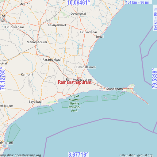
Ramanathapuram GPS coordinates[2]
9° 22' 17.688" North, 78° 49' 50.772" East
| Map corner | latitude | longitude |
|---|---|---|
| Upper-left | 10.06461°, | 78.12765° |
| Center: | 9.37158°, | 78.83077° |
| Lower-right: | 8.67716°, | 79.5339° |
| Map W x H: | 154.3×154.3 km | = 95.9×95.9mi |
| max Lat: | 34.9274° ⇑98% North |
| Ramanathapuram: | 9.37158° |
| min Lat: | ⇓2% South 8.09008° |
| min Long | Ramanathapuram | max Long |
| 68.82655° | 78.83077° | 96.81° |
| W 57.4%⇐ | ⇒42.6% E |
Elevation
Elevation of Ramanathapuram is 10 m = 33 ft, and this is 285.6 m = 937 ft below average elevation for this country.
| Max E: |
3681 m = 12077 ft | 96.4% |
| Avg. | 295.6 m = 970 ft | |
| Ramanathapuram | 10 m = 33 ft | |
Min E: |
1 m = 3 ft | 3.6% |
See also: Ramanathapuram elevation on elevation.city.
Geographical zone
Ramanathapuram is located in North Torrid zone (between Equator and Tropic of Cancer). Distance of Equator is 1042 km =647.5 mi to South.| Distance of | km | miles | from Ramanathapuram |
|---|---|---|---|
| North Pole | 8965 | 5570.6 | to North |
| Arctic Circle | 6359.2 | 3951.4 | to North |
| Tropic Cancer | 1563.9 | 971.8 | to North |
| Equator | 1042 | 647.5 | to South |


Nearby cities:
15 places around Ramanathapuram: (largest is in red/bold)
• Abirāmam
43.6 km =27.1 mi,  280°
280°
• Kamuthi
50.3 km =31.3 mi,  274°
274°
• Keelakarai
16.3 km =10.1 mi,  197°
197°
• Manamadurai
51.8 km =32.2 mi,  310°
310°
• Mandapam
33.9 km =21.1 mi,  108°
108°
• Mangalam
48.4 km =30.1 mi,  334°
334°
• Mudukulattūr
34.9 km =21.7 mi,  264°
264°
• Nambutalai
44.1 km =27.4 mi,  26°
26°
• Nāttarasankottai
63.1 km =39.2 mi, 331°
• Paramagudi
32.7 km =20.3 mi, 306°
• Periyapattinam
13.5 km =8.4 mi,  144°
144°
• Rameswaram
53.7 km =33.4 mi,  99°
99°
• Sāyalkudi
47.7 km =29.6 mi,  241°
241°
• Tiruppālaikudi
21.6 km =13.4 mi, 26°
• Tondi
46 km =28.6 mi, 26°
Sources, notices
• [Note1] Compared only with cities in India existing in our database
• [Src1] Map data: © OpenStreetMap contributors (CC-BY-SA)
• [Src2] Other city data from geonames.org with taken over terms of usage.
• [Src3] Geographical zone / Annual Mean Temperature by Robert A. Rohde @ Wikipedia
