Periyapattinam geodata
Periyapattinam (Tamil Nadu) is a populated place; located in India in Asia/Kolkata (GMT+5.5) time zone. With population of 9,478 people, there are 2996 cities with bigger population in this country. Compared to other cities in India, 98.3% of cities are located further ↑North; 58.1% of cities are located further ←West and 98.3% of cities have higher elevation than Periyapattinam. Note1


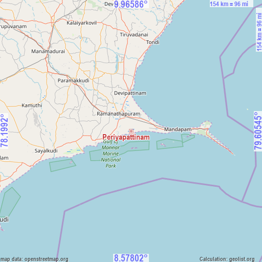
Periyapattinam GPS coordinates[2]
9° 16' 21.468" North, 78° 54' 8.352" East
| Map corner | latitude | longitude |
|---|---|---|
| Upper-left | 9.96586°, | 78.1992° |
| Center: | 9.27263°, | 78.90232° |
| Lower-right: | 8.57802°, | 79.60545° |
| Map W x H: | 154.3×154.3 km | = 95.9×95.9mi |
| max Lat: | 34.9274° ⇑98.3% North |
| Periyapattinam: | 9.27263° |
| min Lat: | ⇓1.7% South 8.09008° |
| min Long | Periyapattinam | max Long |
| 68.82655° | 78.90232° | 96.81° |
| W 58.1%⇐ | ⇒41.9% E |
Elevation
Elevation of Periyapattinam is 8 m = 26 ft, and this is 287.6 m = 944 ft below average elevation for this country.
| Max E: |
3681 m = 12077 ft | 98.3% |
| Avg. | 295.6 m = 970 ft | |
| Periyapattinam | 8 m = 26 ft | |
Min E: |
1 m = 3 ft | 1.7% |
See also: India elevation on elevation.city.
Geographical zone
Periyapattinam is located in North Torrid zone (between Equator and Tropic of Cancer). Distance of Equator is 1031 km =640.6 mi to South.| Distance of | km | miles | from Periyapattinam |
|---|---|---|---|
| North Pole | 8976 | 5577.4 | to North |
| Arctic Circle | 6370.2 | 3958.3 | to North |
| Tropic Cancer | 1574.9 | 978.6 | to North |
| Equator | 1031 | 640.6 | to South |


Nearby cities:
15 places around Periyapattinam: (largest is in red/bold)
• Abirāmam
54.1 km =33.6 mi,  290°
290°
• Devakottai
75.5 km =46.9 mi,  353°
353°
• Kamuthi
59.9 km =37.2 mi,  284°
284°
• Keelakarai
13.6 km =8.5 mi,  250°
250°
• Manamadurai
65 km =40.4 mi,  313°
313°
• Mandapam
24.3 km =15.1 mi,  89°
89°
• Mangalam
61.8 km =38.4 mi,  332°
332°
• Mudukulattūr
43.3 km =26.9 mi, 280°
• Nambutalai
51.9 km =32.2 mi,  12°
12°
• Paramagudi
45.8 km =28.5 mi, 311°
• Ramanathapuram
13.5 km =8.4 mi,  324°
324°
• Rameswaram
45.1 km =28 mi, 87°
• Sāyalkudi
51.3 km =31.9 mi,  257°
257°
• Tiruppālaikudi
30.4 km =18.9 mi,  3°
3°
• Tondi
53.7 km =33.4 mi, 13°
Sources, notices
• [Note1] Compared only with cities in India existing in our database
• [Src1] Map data: © OpenStreetMap contributors (CC-BY-SA)
• [Src2] Other city data from geonames.org with taken over terms of usage.
• [Src3] Geographical zone / Annual Mean Temperature by Robert A. Rohde @ Wikipedia
