Numāligarh geodata
Numāligarh (Assam) is a populated place; located in India in Asia/Kolkata (GMT+5.5) time zone. With population of 7,386 people, there are 3182 cities with bigger population in this country. Compared to other cities in India, 75.6% of cities are located further ↓South; 98.3% of cities are located further ←West and 68.7% of cities have higher elevation than Numāligarh. Note1


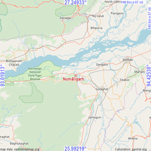
Numāligarh GPS coordinates[2]
26° 37' 20.964" North, 93° 43' 20.1" East
| Map corner | latitude | longitude |
|---|---|---|
| Upper-left | 27.24933°, | 93.01913° |
| Center: | 26.62249°, | 93.72225° |
| Lower-right: | 25.99219°, | 94.42538° |
| Map W x H: | 139.8×139.8 km | = 86.9×86.9mi |
| max Lat: | 34.9274° ⇑24.4% North |
| Numāligarh: | 26.62249° |
| min Lat: | ⇓75.6% South 8.09008° |
| min Long | Numāligarh | max Long |
| 68.82655° | 93.72225° | 96.81° |
| W 98.3%⇐ | ⇒1.7% E |
Elevation
Elevation of Numāligarh is 99 m = 325 ft, and this is 196.6 m = 645 ft below average elevation for this country.
| Max E: |
3681 m = 12077 ft | 68.7% |
| Avg. | 295.6 m = 970 ft | |
| Numāligarh | 99 m = 325 ft | |
Min E: |
1 m = 3 ft | 31.3% |
See also: India elevation on elevation.city.
Geographical zone
Numāligarh is located in North temperate zone (between Tropic of Cancer and the Arctic Circle). Distance of this Northern Tropic circle is 354.2 km =220.1 mi to South.| Distance of | km | miles | from Numāligarh |
|---|---|---|---|
| North Pole | 7046.9 | 4378.7 | to North |
| Arctic Circle | 4441 | 2759.5 | to North |
| Tropic Cancer | 354.2 | 220.1 | to South |
| Equator | 2960.1 | 1839.3 | to South |


Nearby cities:
15 places around Numāligarh: (largest is in red/bold)
• Barpathār
40.8 km =25.4 mi,  156°
156°
• Bihpuriāgaon
47.9 km =29.8 mi,  23°
23°
• Biswanath Chariali
58.3 km =36.2 mi,  281°
281°
• Bokajān
67.1 km =41.7 mi,  175°
175°
• Bokākhāt
12.3 km =7.6 mi, 279°
• Dergaon
25.8 km =16 mi,  70°
70°
• Garamur
57.5 km =35.7 mi,  50°
50°
• Gohpur
30.7 km =19.1 mi,  339°
339°
• Golāghāt
26.6 km =16.5 mi,  117°
117°
• Itānagar
52.8 km =32.8 mi,  347°
347°
• Jorhāt
50.1 km =31.1 mi, 72°
• Mariāni
59.1 km =36.7 mi,  86°
86°
• Naharlagun
53.7 km =33.4 mi,  357°
357°
• North Lakhimpur
77.9 km =48.4 mi,  29°
29°
• Titābar
47.9 km =29.8 mi, 92°
Sources, notices
• [Note1] Compared only with cities in India existing in our database
• [Src1] Map data: © OpenStreetMap contributors (CC-BY-SA)
• [Src2] Other city data from geonames.org with taken over terms of usage.
• [Src3] Geographical zone / Annual Mean Temperature by Robert A. Rohde @ Wikipedia
