Bokākhāt geodata
Bokākhāt (Assam) is a populated place; located in India in Asia/Kolkata (GMT+5.5) time zone. With population of 9,554 people, there are 2990 cities with bigger population in this country. Compared to other cities in India, 75.6% of cities are located further ↓South; 98.1% of cities are located further ←West and 71.5% of cities have higher elevation than Bokākhāt. Note1


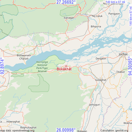
Bokākhāt GPS coordinates[2]
26° 38' 24.648" North, 93° 36' 1.872" East
| Map corner | latitude | longitude |
|---|---|---|
| Upper-left | 27.26692°, | 92.8974° |
| Center: | 26.64018°, | 93.60052° |
| Lower-right: | 26.00998°, | 94.30365° |
| Map W x H: | 139.8×139.8 km | = 86.9×86.9mi |
| max Lat: | 34.9274° ⇑24.4% North |
| Bokākhāt: | 26.64018° |
| min Lat: | ⇓75.6% South 8.09008° |
| min Long | Bokākhāt | max Long |
| 68.82655° | 93.60052° | 96.81° |
| W 98.1%⇐ | ⇒1.9% E |
Elevation
Elevation of Bokākhāt is 86 m = 282 ft, and this is 209.6 m = 688 ft below average elevation for this country.
| Max E: |
3681 m = 12077 ft | 71.5% |
| Avg. | 295.6 m = 970 ft | |
| Bokākhāt | 86 m = 282 ft | |
Min E: |
1 m = 3 ft | 28.5% |
See also: India elevation on elevation.city.
Geographical zone
Bokākhāt is located in North temperate zone (between Tropic of Cancer and the Arctic Circle). Distance of this Northern Tropic circle is 356.2 km =221.3 mi to South.| Distance of | km | miles | from Bokākhāt |
|---|---|---|---|
| North Pole | 7045 | 4377.6 | to North |
| Arctic Circle | 4439.1 | 2758.3 | to North |
| Tropic Cancer | 356.2 | 221.3 | to South |
| Equator | 2962.1 | 1840.6 | to South |


Nearby cities:
15 places around Bokākhāt: (largest is in red/bold)
• Barpathār
48.6 km =30.2 mi,  143°
143°
• Bihpuriāgaon
52.4 km =32.6 mi,  36°
36°
• Biswanath Chariali
46.1 km =28.6 mi,  281°
281°
• Bokajān
71.1 km =44.2 mi,  165°
165°
• Dergaon
37 km =23 mi,  79°
79°
• Garamur
66.3 km =41.2 mi,  58°
58°
• Gohpur
26.9 km =16.7 mi,  3°
3°
• Golāghāt
38.5 km =23.9 mi,  111°
111°
• Itānagar
49.7 km =30.9 mi, 1°
• Jorhāt
61.3 km =38.1 mi, 77°
• Mariāni
71.1 km =44.2 mi,  88°
88°
• Naharlagun
52.5 km =32.6 mi,  10°
10°
• Numāligarh
12.3 km =7.6 mi,  99°
99°
• Tezpur
79.6 km =49.5 mi,  269°
269°
• Titābar
60.1 km =37.3 mi, 94°
Sources, notices
• [Note1] Compared only with cities in India existing in our database
• [Src1] Map data: © OpenStreetMap contributors (CC-BY-SA)
• [Src2] Other city data from geonames.org with taken over terms of usage.
• [Src3] Geographical zone / Annual Mean Temperature by Robert A. Rohde @ Wikipedia
