Tekkalakote geodata
Tekkalakote (Karnataka) is a populated place; located in India in Asia/Kolkata (GMT+5.5) time zone. With population of 25,530 people, there are 1664 cities with bigger population in this country. Compared to other cities in India, 79.6% of cities are located further ↑North; 64.5% of cities are located further →East and 75.9% of cities have lower elevation than Tekkalakote. Note1


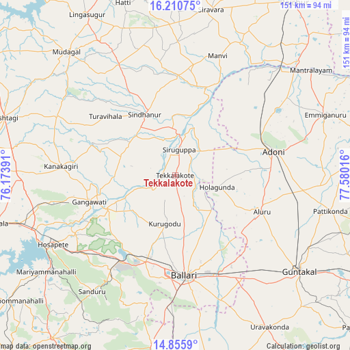
Tekkalakote GPS coordinates[2]
15° 32' 3.984" North, 76° 52' 37.308" East
| Map corner | latitude | longitude |
|---|---|---|
| Upper-left | 16.21075°, | 76.17391° |
| Center: | 15.53444°, | 76.87703° |
| Lower-right: | 14.8559°, | 77.58016° |
| Map W x H: | 150.6×150.6 km | = 93.6×93.6mi |
| max Lat: | 34.9274° ⇑79.6% North |
| Tekkalakote: | 15.53444° |
| min Lat: | ⇓20.4% South 8.09008° |
| min Long | Tekkalakote | max Long |
| 68.82655° | 76.87703° | 96.81° |
| W 35.5%⇐ | ⇒64.5% E |
Elevation
Elevation of Tekkalakote is 398 m = 1306 ft, and this is 102.4 m = 336 ft above average elevation for this country.
| Max E: |
3681 m = 12077 ft | 24.1% |
| Tekkalakote | 398 m 1306 ft | |
| Avg. | 295.6 m = 970 ft | |
Min E: |
1 m = 3 ft | 75.9% |
See also: India elevation on elevation.city.
Geographical zone
Tekkalakote is located in North Torrid zone (between Equator and Tropic of Cancer). Distance of this Northern Tropic circle is 878.7 km =546 mi to North.| Distance of | km | miles | from Tekkalakote |
|---|---|---|---|
| North Pole | 8279.8 | 5144.8 | to North |
| Arctic Circle | 5673.9 | 3525.6 | to North |
| Tropic Cancer | 878.7 | 546 | to North |
| Equator | 1727.3 | 1073.3 | to South |


Nearby cities:
15 places around Tekkalakote: (largest is in red/bold)
• Bellary
43.9 km =27.3 mi,  173°
173°
• Emmiganūr
70.1 km =43.6 mi,  67°
67°
• Gangāwati
39 km =24.2 mi,  252°
252°
• Guntakal Junction
65.9 km =40.9 mi,  127°
127°
• Hampi
49.9 km =31 mi,  243°
243°
• Hospet
60.2 km =37.4 mi, 240°
• Kampli
32.9 km =20.4 mi, 244°
• Kosigi
53.1 km =33 mi,  47°
47°
• Mudgal
70.6 km =43.9 mi,  318°
318°
• Munirābād
62.9 km =39.1 mi, 246°
• Mānvi
54.1 km =33.6 mi,  20°
20°
• Sandūr
61.1 km =38 mi,  215°
215°
• Sindhnūr
29.2 km =18.1 mi,  333°
333°
• Siruguppa
10.7 km =6.6 mi,  8°
8°
• Ādoni
43.9 km =27.3 mi,  76°
76°
Sources, notices
• [Note1] Compared only with cities in India existing in our database
• [Src1] Map data: © OpenStreetMap contributors (CC-BY-SA)
• [Src2] Other city data from geonames.org with taken over terms of usage.
• [Src3] Geographical zone / Annual Mean Temperature by Robert A. Rohde @ Wikipedia
