Bellary geodata
Bellary (Karnataka) is a populated place; located in India in Asia/Kolkata (GMT+5.5) time zone. With population of 336,681 people, there are 126 cities with bigger population in this country. Compared to other cities in India, 81.4% of cities are located further ↑North; 64.1% of cities are located further →East and 79.8% of cities have lower elevation than Bellary. Note1


Bellary GPS coordinates[2]
15° 8' 31.38" North, 76° 55' 26.328" East
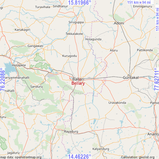
| Map corner | latitude | longitude |
|---|---|---|
| Upper-left | 15.81966°, | 76.22086° |
| Center: | 15.14205°, | 76.92398° |
| Lower-right: | 14.46226°, | 77.62711° |
| Map W x H: | 150.9×150.9 km | = 93.8×93.8mi |
| max Lat: | 34.9274° ⇑81.4% North |
| Bellary: | 15.14205° |
| min Lat: | ⇓18.6% South 8.09008° |
| min Long | Bellary | max Long |
| 68.82655° | 76.92398° | 96.81° |
| W 35.9%⇐ | ⇒64.1% E |
Elevation
Elevation of Bellary is 456 m = 1496 ft, and this is 160.4 m = 526 ft above average elevation for this country.
| Max E: |
3681 m = 12077 ft | 20.2% |
| Bellary | 456 m 1496 ft | |
| Avg. | 295.6 m = 970 ft | |
Min E: |
1 m = 3 ft | 79.8% |
See also: Bellary elevation on elevation.city.
Geographical zone
Bellary is located in North Torrid zone (between Equator and Tropic of Cancer). Distance of this Northern Tropic circle is 922.3 km =573.1 mi to North.| Distance of | km | miles | from Bellary |
|---|---|---|---|
| North Pole | 8323.4 | 5171.9 | to North |
| Arctic Circle | 5717.5 | 3552.7 | to North |
| Tropic Cancer | 922.3 | 573.1 | to North |
| Equator | 1683.6 | 1046.1 | to South |


Nearby cities:
15 places around Bellary: (largest is in red/bold)
• Gangāwati
53.2 km =33.1 mi,  307°
307°
• Guntakal Junction
47.2 km =29.3 mi,  86°
86°
• Hampi
54.2 km =33.7 mi,  293°
293°
• Hospet
59.3 km =36.8 mi,  283°
283°
• Kalyandurg
69.2 km =43 mi,  163°
163°
• Kampli
45.5 km =28.3 mi, 310°
• Kūdligi
63.6 km =39.5 mi,  245°
245°
• Munirābād
65.5 km =40.7 mi, 286°
• Rāyadrug
49.8 km =30.9 mi,  188°
188°
• Sandūr
40.9 km =25.4 mi,  261°
261°
• Sindhnūr
72.1 km =44.8 mi,  345°
345°
• Siruguppa
54.4 km =33.8 mi,  356°
356°
• Tekkalakote
43.9 km =27.3 mi, 353°
• Uravakonda
41.8 km =26 mi,  121°
121°
• Ādoni
65.8 km =40.9 mi,  34°
34°
Sources, notices
• [Note1] Compared only with cities in India existing in our database
• [Src1] Map data: © OpenStreetMap contributors (CC-BY-SA)
• [Src2] Other city data from geonames.org with taken over terms of usage.
• [Src3] Geographical zone / Annual Mean Temperature by Robert A. Rohde @ Wikipedia
